 Filter: Subject of rivers
Filter: Subject of courthouses
Filter: Subject of rivers
Filter: Subject of courthouses

| Date: | 1870 |
|---|---|
| Description: | Baraboo was first settled around 1838, and by 1870 it had become the county seat and the thriving village illustrated here. This birds eye drawing depicts ... |

| Date: | 1867 |
|---|---|
| Description: | Bird's-eye map of Green Bay and Fort Howard, Brown Co., depicts street names and street layouts, houses, trees, and the East River. A reference key at the ... |

| Date: | 1870 |
|---|---|
| Description: | Bird's-eye map of Hudson, with insets of Court House and Public School. |

| Date: | 1870 |
|---|---|
| Description: | Although the first European settlement in Jefferson was in 1836, the Village of Jefferson was first incorporated as a city in 1878. Made eight years earlie... |

| Date: | 1898 |
|---|---|
| Description: | Bird's-eye map of Milwaukee with prominent streets and buildings identified. Taken from City Hall Tower. |

| Date: | 1883 |
|---|---|
| Description: | Bird's-eye map of Superior, county seat of Douglas County, on the shores of Lake Superior, with insets of points of interest. |

| Date: | 1875 |
|---|---|
| Description: | Bird's-eye map of Black River Falls, looking southwest. |

| Date: | 1874 |
|---|---|
| Description: | Bird's-eye view of Waukesha, looking southwest, with insets of State Industrial School, Court House, and Fountain Spring House. |

| Date: | 1859 |
|---|---|
| Description: | Map featuring various views of buildings and scenes from Sauk County. |
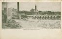
| Date: | 1909 |
|---|---|
| Description: | The Lindaur Mill Flume. A man is standing in the left foreground. In the distance is the Court House with clocktower. Caption reads: "Lindaur Mill Flume, M... |
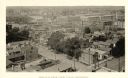
| Date: | 1888 |
|---|---|
| Description: | Elevated view from the northwest of the Racine Court House. Caption reads: "Birds-Eye from Court House, Northwest." |
| Date: | |
|---|---|
| Description: | View from shoreline of a covered bridge over the Susquehannah River, with the Bradford county courthouse and other town buildings visible on the opposite s... |

| Date: | |
|---|---|
| Description: | Bird's-eye view of the north branch extension canal on the Susquehanna river, surrounded by smaller renderings of structures of interest around the town in... |
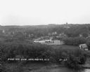
| Date: | 1929 |
|---|---|
| Description: | Elevated view of town looking down a hill. In the foreground is a river with trees along the bank. On the other side of the river is a factory with industr... |
| Date: | 1929 |
|---|---|
| Description: | View down tree-lined hill over the Pecatonica River. The bridge connects River Street to Main Street. Storefronts line the street, and the Lafayette County... |

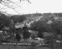
| Date: | 1947 |
|---|---|
| Description: | Shows lot and block numbers, 28 points of interest in the upper left that correspond to numbers on the map, and landownership with acreages. "Erickson Brot... |

| Date: | 1800 |
|---|---|
| Description: | Shows plat of town, land ownership by name, local streets, courthouses, churches, hotels, mills, railroads, railroad stations, lakes, and rivers. Includes ... |
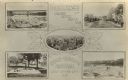
| Date: | 1908 |
|---|---|
| Description: | Photographic postcard view of five framed images from around Black River Falls; the bridge crossing the river, Main Street, the Court House Yard and founta... |

| Date: | 1911 |
|---|---|
| Description: | View from shoreline looking across the dam in front. Black River Falls is on the opposite shoreline, with several wooden structures, including the power ho... |

| Date: | 1857 |
|---|---|
| Description: | This map shows rural landownership and acreages, lot and block numbers, selected buildings, roads, railroads, and public squares. The map is indexed for th... |
If you didn't find the material you searched for, our Library Reference Staff can help.
Call our reference desk at 608-264-6535 or email us at: