 Filter: Subject of rivers
Filter: Subject of flowers
Filter: Subject of rivers
Filter: Subject of flowers
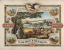
| Date: | 1876 |
|---|---|
| Description: | Color chromolithograph illustration advertising poster for the Marsh Harvester, produced by Gammon and Deering Company. Printed by Charles Shober & Co., Ch... |
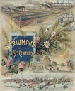
| Date: | 1893 |
|---|---|
| Description: | Cover of an advertising catalog for William Deering & Company featuring chromolithograph illustrations of the Deering factory, the grain center of the worl... |
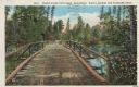
| Date: | 1913 |
|---|---|
| Description: | Colorized postcard of a wooden bridge over the Brule River flowing through the forest. A person is on the far side of the bridge. Caption reads: "Brule Riv... |
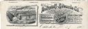
| Date: | |
|---|---|
| Description: | Memohead of the Buckstaff-Edwards Company of Oshkosh, Wisconsin, manufacturers of coffins and caskets and wholesale dealers in caskets and undertaking supp... |
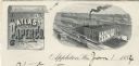
| Date: | |
|---|---|
| Description: | Letterhead of the Atlas Paper Company of Appleton, Wisconsin, a paper company established in 1878. On the left is a scroll embellished with a spray of flow... |
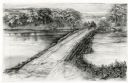
| Date: | 1948 |
|---|---|
| Description: | Drawing depicting a horse-drawn carriage crossing a stone and log causeway built across a river. |

| Date: | 07 1991 |
|---|---|
| Description: | "Les Beck draws water from the Rock River to water eight colorful flower boxes put up by the Theresa Lions Club." |

| Date: | 1919 |
|---|---|
| Description: | Colorized postcard of an elevated view of a concrete bridge over a river. There is a boat near wooden pilings that stretch from the shoreline to the center... |

| Date: | 04 1980 |
|---|---|
| Description: | Shortly after their wedding at Saint Theresa Catholic Church, Eugene Bodden and his bride, Linda Johnson prepare to leave the church in a manure spreader. |
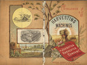
| Date: | 1886 |
|---|---|
| Description: | Front and back cover of a catalog for harvesting machines. The cover features a color illustration of shocks of hay in a field surrounded by sun rays in th... |
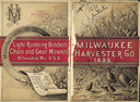
| Date: | 1888 |
|---|---|
| Description: | Front and back cover of catalog, featuring on the front an illustration of birds, mice, and flying insects near a wheat field. The back cover reads: "Manuf... |

| Date: | 1920 |
|---|---|
| Description: | Looking at west De Pere from the east side. Shrubs and foliage are in the foreground. There are buildings and trees on the opposite shoreline. Caption read... |

| Date: | 1957 |
|---|---|
| Description: | View along the shoreline of a river or lake. There are several houses or cabins on the shoreline. |
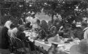
| Date: | 1897 |
|---|---|
| Description: | The Meinhardt family assembled for a picnic in their garden. A river or lake is in the far background. The table is set with china and flatware. Among the ... |

| Date: | 1780 |
|---|---|
| Description: | This map portrays North and South America at a very unusual angle, with north oriented towards the upper right corner. Colonies, Native American land, a fe... |

| Date: | 1759 |
|---|---|
| Description: | Map of North and South America showing regions, colonies, cities and settlements, rivers, lakes, and Native American land. Near the bottom left an inset ma... |

| Date: | 1763 |
|---|---|
| Description: | Map of America and part of Canada including the borders of European claims after the French and Indian War. Cities, forts, Native American lands, rivers, l... |

| Date: | 1755 |
|---|---|
| Description: | Map of colonial America, showing the lands north of South Carolina and west of the Mississippi River. An inset map of the Carolinas and Georgia sits in the... |

| Date: | 1780 |
|---|---|
| Description: | Detailed map of America east of the Louisiana region. It shows forts, cities, borders and boundary lines, Native American land, the post road, mountains, w... |
If you didn't find the material you searched for, our Library Reference Staff can help.
Call our reference desk at 608-264-6535 or email us at:
