 Filter: Subject of rivers
Filter: Subject of gardens
Filter: Subject of rivers
Filter: Subject of gardens

| Date: | 1878 |
|---|---|
| Description: | Bird's-eye map of Chilton with insets of points of interest, including P.H. Becker's Brewery, Chilton House, and Gutheil's Block. |
| Date: | |
|---|---|
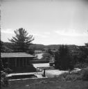
| Description: | Exterior of Frank Lloyd Wright's bedroom, looking southeast, at Taliesin, the summer home of Frank Lloyd Wright. In the courtyard is a sculpture near a poo... |
| Date: | |
|---|---|
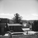
| Description: | Elevated exterior view of Taliesin looking towards Frank Lloyd Wright's bedroom and the terrace off his bedroom as seen from the garden. Taliesin was the ... |

| Date: | |
|---|---|
| Description: | View over town, including hotel and church, towards the Mississippi River. The far shoreline and bluffs are in the distance. |

| Date: | |
|---|---|
| Description: | Aerial view of a monastery and college with other buildings and landscaping. |

| Date: | 1883 |
|---|---|
| Description: | This map shows ward boundaries, names of additions, streets, bridges, mills, schools, religious buildings, businesses, hotels, railroads, factories, brewer... |

| Date: | 1956 |
|---|---|
| Description: | This map shows Lake Wisconsin, roads, highways, parks, resort areas, camps, gardens, and Wisconsin State experimental game and fur farm. The back of the ma... |
| Date: | 1897 |
|---|---|
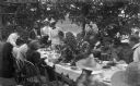
| Description: | The Meinhardt family assembled for a picnic in their garden. A river or lake is in the far background. The table is set with china and flatware. Among the ... |

| Date: | 1930 |
|---|---|
| Description: | A map of the site of a Native American village with a complex of linear raised garden beds and cache pits near Leeman. Also shown are a farmstead, road, an... |

| Date: | 1990 |
|---|---|
| Description: | This map, in addition to the Fort ground and buildings, shows owners of outbuildings, heights of buildings in stories, fences, roads, gardens, and cemetery... |

| Date: | 1776 |
|---|---|
| Description: | Fairly detailed map of New York City and parts of Long Island. It shows streets, roads, wharves, ferries, ship yards, Fort George and the battery, public b... |

| Date: | 1793 |
|---|---|
| Description: | Detailed topographical map of the Ohio River between Clarkville and Louisville. It shows plots of farmland, forest, islands, garden plots, houses, Fort Fe... |

| Date: | 1608 |
|---|---|
| Description: | Illustraiton, with alphabetical key in French, of the Habitation of Quebec, a conglomeration of connected buildings on the banks of the St. Lawrence River ... |
If you didn't find the material you searched for, our Library Reference Staff can help.
Call our reference desk at 608-264-6535 or email us at: