 Filter: Subject of rivers
Filter: Subject of historic sites
Filter: Subject of rivers
Filter: Subject of historic sites
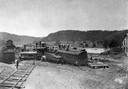
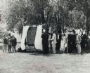
| Date: | 1898 |
|---|---|
| Description: | Elevated view of the Kickapoo & Northern Railway locomotive and cars seen here after being derailed due to flooding on the Kickapoo River. |
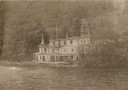
| Date: | |
|---|---|
| Description: | "Crazy Man's Castle" near Minneiska, Minnesota. Built of lumber salvaged from Mississippi River log and lumber rafts which occasionally lost some of their ... |
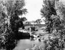
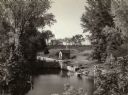
| Date: | 1935 |
|---|---|
| Description: | Elevated view of the Portage canal and lock, with the Indian Agency House in the center background. The canal was dug in 1849 as part of the Fox-Wisconsin ... |
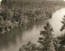
| Date: | 1940 |
|---|---|
| Description: | Elevated view of a canoe on the St. Croix River with wooded areas on both sides within the Interstate State Park. Established in 1900, Interstate Park was... |

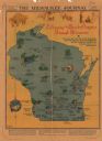
| Date: | 1939 |
|---|---|
| Description: | A color, pictorial map. Scale: 10 miles to the inch. Shows state parks and forests, proposed state parkways, proposed state monuments and memorials, nation... |

| Date: | 1948 |
|---|---|
| Description: | Buildings at "Little Norway." From left to right: tool house, Norway house, Haugen homestead. The wagon in foreground is a kubberulle; the wheels are sec... |
| Date: | 1935 |
|---|---|
| Description: | Elevated view of the Indian Agency House near the site of Fort Winnebago. View of Portage Canal in foreground. The canal was dug in 1849 as part of the Fox... |
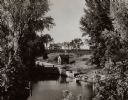
| Date: | 1935 |
|---|---|
| Description: | A view of the Portage Canal and lock. The Indian Agency House in the center background. The canal was dug in 1849 as part of the Fox-Wisconsin waterway pro... |
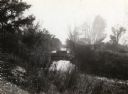
| Date: | 1935 |
|---|---|
| Description: | A view of the Portage Canal. In the immediate foreground is the Fox River, then the lower locks and the canal itself. The Indian Agency House may be seen t... |
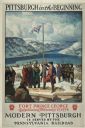
| Date: | 1930 |
|---|---|
| Description: | An original lithograph promoting Pittsburgh, Pennsylvania, and the Pennsylvania Railroad through artist N.C. Wyeth's depiction of the establishment of Fort... |
| Date: | 1931 |
|---|---|
| Description: | This map "sets out the more important points of historic interest designated by the National Society of Colonial Dames in Wisconsin" and includes illustrat... |

| Date: | 1941 |
|---|---|
| Description: | This pictorial map of Wisconsin with historical text highlights the history of the state and identifies places of interest, Indian villages, missions, trad... |
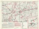
| Date: | |
|---|---|
| Description: | This map shows the locations of historic sites and points of interest in Rusk County, Wisconsin. A location key, descriptions of the historical importance ... |
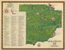
| Date: | 1975 |
|---|---|
| Description: | This 1975 map of Sauk County, Wisconsin, lists and locates historic sites and other points of interest in the county. |
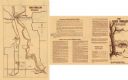
| Date: | 1974 |
|---|---|
| Description: | This 1974 map shows historical sites related to Caddie Woodlawn, a book by Carol Ryrie Brink, in the Town of Dunn, Dunn County, Wisconsin. Some landmarks a... |
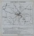
| Date: | 1930 |
|---|---|
| Description: | Shows points of historic interest in Dane County; includes explanation of historical points of interest and corresponding symbols. "Map of historic sites i... |

| Date: | 12 1992 |
|---|---|
| Description: | Built in 1916, the Theresa Village Dam has played a large part in the appearance of the Rock River. Dam is pictured in winter. |

| Date: | 1950 |
|---|---|
| Description: | Front view of George Washington's Mount Vernon from the circular driveway. A line of people are waiting at the entrance. The cupola on the roof has a weath... |

| Date: | 1994 |
|---|---|
| Description: | This map shows historical sites, picnic grounds, public boat landings, canoe and motor boat trips, and resort locations. The left margin of the map include... |
| Date: | 06 30 1957 |
|---|---|
| Description: | View across lawn towards a crowd, with costumed participants dressed as Native Americans, fur traders, and Jacques Marquette, at the dedication of the Marq... |
If you didn't find the material you searched for, our Library Reference Staff can help.
Call our reference desk at 608-264-6535 or email us at: