 Filter: Subject of rivers
Filter: Subject of sailing ships
Filter: Subject of rivers
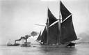
Filter: Subject of sailing ships
| Date: | |
|---|---|
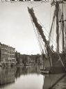
| Description: | Schooners docked on river. The view is downriver from the Grand Avenue Bridge. |

| Date: | 1855 |
|---|---|
| Description: | Quarter plate daguerreotype of the Oshkosh harbor, showing the bridge over the Fox River and several moored sailing vessels. |
| Date: | |
|---|---|
| Description: | View downriver from the State Street Bridge showing a large sailing vessel. |
| Date: | |
|---|---|
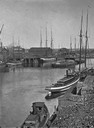
| Description: | View down the river toward the Bay from Walker's Point Bridge, showing several steamboats. |
| Date: | |
|---|---|
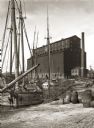
| Description: | View of old sailing boats at a shoreline with elevator A in the background. |
| Date: | |
|---|---|
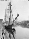
| Description: | The schooner "Azov of Hamilton" on the River St. Clair. The "Azov of Hamilton" was a 108 foot, 195 ton Canadian schooner built in 1866. |
| Date: | 1832 |
|---|---|
| Description: | Camp of the Gros Ventres along the upper Missouri River, with white travelers passing by in a boat. |

| Date: | 1853 |
|---|---|
| Description: | Bird's-eye map of Milwaukee looking east toward Lake Michigan from a bluff, long since graded into a slope, at about 6th Street between Wisconsin Avenue an... |
| Date: | |
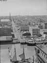
|---|---|
| Description: | Elevated view west from Mitchell Block of warehouses, industrial buildings and a church in the background. In the foreground is a waterway with a schooner ... |
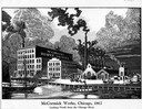
| Date: | 1867 |
|---|---|
| Description: | Engraving of the McCormick Reaper Works as it appeared in 1867. The factory was located on the north bank of the Chicago River, east of the Rush Street bri... |

| Date: | 1885 |
|---|---|
| Description: | Bird's-eye map of Oconomowoc. |

| Date: | 1874 |
|---|---|
| Description: | Bird's-eye map of Racine, with an inset of Racine College. |

| Date: | 1879 |
|---|---|
| Description: | Bird's-eye map of Two Rivers. |

| Date: | 1870 |
|---|---|
| Description: | Bird's-eye view of Whitewater, with insets. |

| Date: | 1854 |
|---|---|
| Description: | Bird's-eye view of Milwaukee looking east toward Lake Michigan from a bluff, long since graded into a slope, at about 6th Street between Wisconsin Avenue a... |

| Date: | 1937 |
|---|---|
| Description: | Bird's-eye view of Milwaukee in 1853 details building features and city layout from southwest. Important buildings are numbered in a silhouette drawing bel... |

| Date: | 1892 |
|---|---|
| Description: | Bird's-eye view of Chicago, with ships in the Lake Michigan harbor. |

| Date: | 1632 |
|---|---|
| Description: | The Wisconsin portion of Champlain's 1632 map, augmented since the previous one, for navigation according to the true Meridien, by Sieur de Champlain. The ... |
| Date: | |
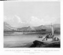
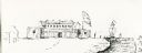
|---|---|
| Description: | View of a fort with fortified walls and a flag flying from the fort. A river runs on the right of the image. A boat with sails floats on the river. Sold... |
If you didn't find the material you searched for, our Library Reference Staff can help.
Call our reference desk at 608-264-6535 or email us at:
