 Filter: Subject of rivers
Filter: Subject of streetcars
Filter: Subject of rivers
Filter: Subject of streetcars

| Date: | 1916 |
|---|---|
| Description: | Southeastern Wisconsin which lies east of Whitewater and south of Port Washington. |

| Date: | 1869 |
|---|---|
| Description: | This map was engraved from original drawings and surveys taken by Louis Lipman. Includes Milwaukee street directory on the left hand side. Bottom right cor... |

| Date: | 1927 |
|---|---|
| Description: | Street railway and motor bus map with a legend of "Street Car Line," "Auxiliary Bus Lines," and "Motor Bus Lines." The routes are numbered. The map reads: ... |

| Date: | 1903 |
|---|---|
| Description: | Map shows railroads, roads, street car lines, schools, churches, cemeteries, town halls, and railroad stations. Includes inset lists of: Population of Milw... |

| Date: | 1960 |
|---|---|
| Description: | Color coded map in pink, yellow, blue, and brown of Milwaukee County State and County trunk highways. The map includes a legend of symbols: "STEAM RAIL ROA... |

| Date: | 1938 |
|---|---|
| Description: | Color coded map in pink, yellow, blue, and brown of Milwaukee County State and County trunk highways. The map includes a legend of symbols: "STEAM RAIL ROA... |
| Date: | 1910 |
|---|---|
| Description: | Color enhanced photographic postcard view of the "new" Barstow Street concrete arch bridge over the Eau Claire River. A street car is crossing the bridge. ... |

| Date: | 1912 |
|---|---|
| Description: | Black and white photographic postcard view of the Grand Avenue bridge across the Chippewa river, looking through the trusses along the streetcar tracks. Ca... |

| Date: | 1901 |
|---|---|
| Description: | This map shows public schools, engine houses, railroads, street railways, city wards, parks, block numbers, and Lake Michigan. Also included are indexes, t... |

| Date: | 1904 |
|---|---|
| Description: | This map has three inset maps of Whitefish Bay, Cudahy, and South Milwaukee. This map depicts schools, engine houses, railroads, street railways, city ward... |

| Date: | 1911 |
|---|---|
| Description: | This map shows ward numbers, streets, railroads, electric car lines, parks, steam railways, section numbers, Lake Michigan and one mile concentric circles ... |

| Date: | 1912 |
|---|---|
| Description: | This map shows ward numbers, streets, railroads, electric car lines, parks, steam railways, section numbers, Lake Michigan and one mile concentric circles ... |

| Date: | 1916 |
|---|---|
| Description: | This map shows ward numbers, streets, railroads, electric car lines, parks, steam railways, section numbers, rivers, Lake Michigan, churches, schools, and ... |

| Date: | 1927 |
|---|---|
| Description: | This map shows highways, roads, a proposed annexation, street car lines, bus routes, local motor bus lines, a new high speed interurban, railroads, a propo... |

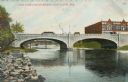
| Date: | |
|---|---|
| Description: | View of a concrete arch bridge crossing the Rock River in downtown Janesville. |

| Date: | 1895 |
|---|---|
| Description: | A view, looking east, across the Milwaukee River. The Grand Avenue Bridge is on the left, which is decorated with bunting and banners, and is crowded with ... |
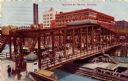
| Date: | 1909 |
|---|---|
| Description: | Color lithograph of elevated view of traffic along the Madison St. bridge. Streetcars, horse-drawn wagons, and pedestrians are on the bridge. Caption reads... |

| Date: | 1975 |
|---|---|
| Description: | Text on reverse reads: "Free Parking Lot Trolley. For your convenience you may ride the trolley from your car to Boat Dock. 'Have a Great Day.' Wisconsin D... |
If you didn't find the material you searched for, our Library Reference Staff can help.
Call our reference desk at 608-264-6535 or email us at: