Filter: Subject of rivers
Filter: Subject of technology
Filter: Subject of rivers
Filter: Subject of technology
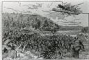
| Date: | 1845 |
|---|---|
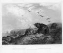
| Description: | Illustration of Chippewa and Sioux Indians battling each other at the Brule River. Wood engraving from Armstrong, "Early Life Among The Indians." |
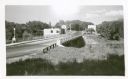
| Date: | 1919 |
|---|---|
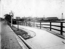
| Description: | Deering Works factory seen across the waterfront from Diversey Avenue. In the foreground is a street and sidewalk with the sign "horse vehicles keep to rig... |
| Date: | |
|---|---|
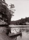
| Description: | Two men dressed as "Indians" are sitting in a canoe at the edge of the beach. One is posing holding a bow and arrow, the other is holding a paddle. |
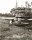
| Date: | |
|---|---|
| Description: | View down sandy beach towards H.H. Bennett and Ruth Bennett on shore near Sugar Bowl. H.H. Bennett is holding a camera over his shoulder. There is an unide... |

| Date: | 1867 |
|---|---|
| Description: | Bird's-eye map of Green Bay and Fort Howard, Brown Co., depicts street names and street layouts, houses, trees, and the East River. A reference key at the ... |

| Date: | 1870 |
|---|---|
| Description: | Bird's-eye view of Whitewater, with insets. |
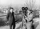
| Date: | 1964 |
|---|---|
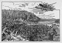
| Description: | Foreign correspondent, Russell Jones, on assignement. Jones worked for ABC News, and is being filmed for an evening news segment on political events in Bud... |
| Date: | 1945 |
|---|---|
| Description: | View towards the Eagle River bridge. Caption reads: "Eagle River Bridge, Eagle River, Wis." |
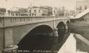
| Date: | 1910 |
|---|---|
| Description: | View of a river and Main Street bridge above the river. Commercial buildings line the street on the opposite side of the bridge. Caption reads: "Main St. B... |
| Date: | |
|---|---|
| Description: | An illustration titled "The Battle of the Brule" based on an 1840's battle between the Ojibwe and Dakota Sioux over territory in the Ashland, Wisconsin are... |
| Date: | 1940 |
|---|---|
| Description: | The bridge over Crawfish River. Buildings are on the other side of the bridge. |
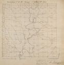
| Date: | |
|---|---|
| Description: | Series 698, General Land Office Survey Plats, vol. 1. |

| Date: | 1905 |
|---|---|
| Description: | Horlick Park, or Island Park, showing the Kinzie Avenue bridge. |

| Date: | |
|---|---|
| Description: | This map surveyed under the direction of Capt. Thomas J. Cram is one in a series of seven. The map shows part of the Fox River and the beginning of the tow... |

| Date: | 1840 |
|---|---|
| Description: | This map surveyed under the direction of Captain Thomas J. Cram is one in a series of seventeen that accompanied Cram's report on the Fox-Wisconsin river s... |

| Date: | 1840 |
|---|---|
| Description: | This map surveyed under the direction of Captain Thomas J. Cram is one in a series of seventeen that accompanied Cram's report on the Fox-Wisconsin river s... |

| Date: | 1876 |
|---|---|
| Description: | Made from U.S. Surveys and from minutes furnished by Jos. S. Buck and Dr. C. Chase. Scale 20 CHs to an inch. |
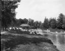
| Date: | 07 19 1914 |
|---|---|
| Description: | Individuals boating in the Kosciusko Park lagoon, with onlookers sitting on the bank. Caption on glass plate reads: "Boating, Kosciusko Park". |
| Date: | |
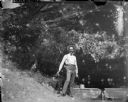
|---|---|
| Description: | Man posed standing with a gun under an overhanging tree near a small wooden dam on a stream. |
If you didn't find the material you searched for, our Library Reference Staff can help.
Call our reference desk at 608-264-6535 or email us at: