 Filter: Subject of road construction industry
Filter: Subject of rivers
Filter: Subject of road construction industry
Filter: Subject of rivers

| Date: | 1910 |
|---|---|
| Description: | Map of the general plan of the district of the Four Lakes. |
| Date: | 1960 |
|---|---|
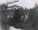
| Description: | Excavation for bridge column footings for the Mirror Lake Bridge. |

| Date: | 1960 |
|---|---|
| Description: | Aerial view of the construction of the interstate highway near Mirror Lake, showing only the early stages of the bridge construction. |
| Date: | 11 16 1960 |
|---|---|
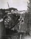
| Description: | Elevated view of the interstate highway bridge construction at Mirror Lake showing the concrete footings halfway down the embankment. |
| Date: | 06 30 1992 |
|---|---|
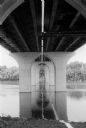
| Description: | View from below of the Fox River Bridge. Gordon Neitzke who photographed the Fox River Bridge for the Wisconsin Department of Highways, found an almost cat... |

| Date: | 1931 |
|---|---|
| Description: | Page from an advertising brochure for International trucks. International trucks are used during the construction of an inter-county bridge between Columbi... |

| Date: | 1976 |
|---|---|
| Description: | An 1876 reprinted map of the Township of Franklin, Milwaukee County, Wisconsin, that shows the land ownership and sectioning of the town, as well as the ro... |

| Date: | 1896 |
|---|---|
| Description: | This 1896 map shows the township and range system, sections, cities and villages, railroads, roads, vacant land and land sold by the Wisconsin Central Rail... |

| Date: | |
|---|---|
| Description: | View along shoreline towards the stone bridge with three arches over the Prairie River. There is a stone wall along the opposite shoreline near the bridge.... |
If you didn't find the material you searched for, our Library Reference Staff can help.
Call our reference desk at 608-264-6535 or email us at: