 Filter: Subject of roads
Filter: Subject of courts
Filter: Subject of roads
Filter: Subject of courts
| Date: | 1905 |
|---|---|
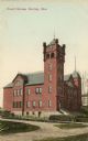
| Description: | View across road toward the court house. Caption reads: "Court House, Hurley, Wis." |

| Date: | 1905 |
|---|---|
| Description: | Color image of courthouse with a large tree and park on the left. View taken at an angle to the building from across the street. Horse-drawn carriages are ... |

| Date: | |
|---|---|
| Description: | Elevated view across the tree lined city park towards the high school, courthouse, and bandstand. |

| Date: | 1845 |
|---|---|
| Description: | Wisconsin was considered part of Michigan Territory until 1836, a year before Michigan entered statehood. Drawn three years before Wisconsin entered stateh... |

| Date: | 1795 |
|---|---|
| Description: | Map of Connecticut showing counties, townships, cities, roads, islands, swamps, hills, mountains, lakes, rivers, reefs, and numerous other geographical and... |

| Date: | 1795 |
|---|---|
| Description: | Map of North Carolina showing counties, cities, towns, courthouses, forts, roads, mountains, swamps, inlets, waterfalls, lakes, and rivers. A dotted square... |

| Date: | 1795 |
|---|---|
| Description: | Map of South Carolina showing the precincts, cities, towns, Native American villages (marked with a triangle), courthouses, roads, mountains, swamps, islan... |
If you didn't find the material you searched for, our Library Reference Staff can help.
Call our reference desk at 608-264-6535 or email us at: