 Filter: Subject of roads
Filter: Subject of fishing
Filter: Subject of roads
Filter: Subject of fishing
| Date: | |
|---|---|
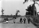
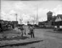
| Description: | Five Mennonite children walking down the middle of the road after a fishing trip. |

| Date: | 1870 |
|---|---|
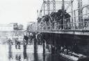
| Description: | Bird's-eye view of Whitewater, with insets. |
| Date: | |
|---|---|
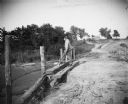
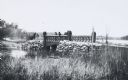
| Description: | A man fishes from an earthen bridge. There is a house or barn in the background. |
| Date: | |
|---|---|
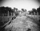
| Description: | Two men fish from an earthen bridge while a woman stands holding a fish. There is a house or barn in the background. |
| Date: | |
|---|---|
| Description: | A road passes in front of the Fish and Gun Club, a two-story building with people sitting and standing on the porch. Another dwelling stands beside it and... |
| Date: | |
|---|---|
| Description: | Fishermen show off their catch on Ocean Avenue in Manasquan Beach. Several dwellings and buildings, a road, automobiles, power lines, and a flag pole are ... |
| Date: | 1870 |
|---|---|
| Description: | A large group of men are snagging sturgeon from a bridge over the Wolf River. A sturgeon is hanging from a line. More men are sitting on a bridge support, ... |
| Date: | |
|---|---|
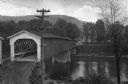
| Description: | Elevated view of a covered bridge spanning the Delaware River. Signs on the bridge read, "$25.00 Fine for Riding or Driving Faster than a Walk on this Brid... |
| Date: | 07 28 1933 |
|---|---|
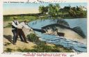
| Description: | Colorized postcard in the Tall-Tale style. Two men standing on the shore are pulling a third man's leg out of a enormous fish's mouth. Two automobiles and ... |
| Date: | 06 08 1959 |
|---|---|
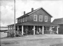
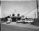
| Description: | Exterior view of Noel's Bait and Sport Shop with cars parked in the lot in front of the building. Fishing nets can be seen on display in the window. The bu... |

| Date: | 1916 |
|---|---|
| Description: | This map shows the locations of hunting and fishing resorts in the northern Wisconsin counties of Forest, Iron, Oneida, and Vilas, and in Gogebic County in... |

| Date: | 1939 |
|---|---|
| Description: | This map shows the towns to Gingles, Sanborn, and Guney as well as Chequamegon Bay, Kakagon River, White River, Marengo River, Bad River, Potato River, Vau... |

| Date: | 1936 |
|---|---|
| Description: | This pictorial tourist map from the Wisconsin Conservation Commission depicts vacation activities and identifies tourist destinations throughout the state.... |
| Date: | 1920 |
|---|---|
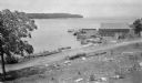
| Description: | View from hill looking down at a wood framed warehouse building on a pier with boats docked alongside. Near the warehouse are fish net drying reels. Wooded... |

| Date: | 1941 |
|---|---|
| Description: | A tourist map of Marinette County, Wisconsin that includes indexes of the lakes and rivers in the county which also identify the fish present, a list of ra... |

| Date: | 1935 |
|---|---|
| Description: | This pictorial map of northern Bayfield County, Wisconsin, shows the Chequamegon National Forest, the Red Cliff Indian Reservation, highways and roads, and... |

| Date: | 1895 |
|---|---|
| Description: | This late 19th century map of northern Wisconsin and a portion of Michigan's Upper Peninsula shows the township and range grid, the (Lac du) Flambeau India... |

| Date: | 1986 |
|---|---|
| Description: | This late 1980s map of Price County, Wisconsin, shows facilities and lands open for public recreation, hunter walking trails and ski trails, campgrounds, b... |

| Date: | 1976 |
|---|---|
| Description: | Panel title. Shows railroads, roads, highways, boundaries, dams, public hunting and fishing grounds, cemeteries, forest ranger stations, plant life, and s... |
| Date: | 1902 |
|---|---|
| Description: | Scene along “Willow Drive,” later known as "University Drive," on the shore of Lake Mendota, showing the neo-Gothic carved bridge. View from shoreline of t... |
If you didn't find the material you searched for, our Library Reference Staff can help.
Call our reference desk at 608-264-6535 or email us at: