 Filter: Subject of roads
Filter: Subject of learning and scholarship
Filter: Subject of roads
Filter: Subject of learning and scholarship
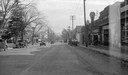
| Date: | 10 30 1935 |
|---|---|
| Description: | View up Monroe Street, looking northeast toward the University of Wisconsin-Madison campus, showing the intersection with Spooner. Also visible are cars, s... |
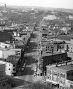
| Date: | 1954 |
|---|---|
| Description: | Elevated view of State Street looking toward Bascom Hall and the University of Wisconsin-Madison campus from the Wisconsin State Capitol dome. |

| Date: | 1908 |
|---|---|
| Description: | A panoramic aerial view of the Isthmus taken from a kite. Lake Mendota is to the right in the background with Picnic Point jutting into the lake. The photo... |
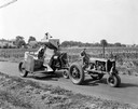
| Date: | 07 03 1934 |
|---|---|
| Description: | Farmer driving a McCormick-Deering Farmall F-20 tractor and combine (harvester-thresher) on a rural highway. The tractor and combine were equipped with Fir... |

| Date: | 1867 |
|---|---|
| Description: | Birds-eye drawing of Appleton, Outagamie Co., depicting street names and street layout, houses, the Fox River, the court house, jail, school houses, Lawren... |

| Date: | 1870 |
|---|---|
| Description: | Although the first European settlement in Jefferson was in 1836, the Village of Jefferson was first incorporated as a city in 1878. Made eight years earlie... |

| Date: | 1852 |
|---|---|
| Description: | Pencil drawing of Madison landscape as seen from University Hill. The main street in the center is State Street, and the building with Greek columns in the... |
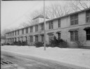
| Date: | 03 01 1945 |
|---|---|
| Description: | Kleinheinz Hall (old Sheep Barn) at 1815 Linden Drive on University of Wisconsin-Madison campus. Building was used as housing for United States Navy Radio ... |
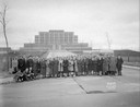
| Date: | 04 21 1939 |
|---|---|
| Description: | Group portrait of students from Madison College, in front of Forest Products Laboratory, 709 Highland Avenue. |

| Date: | 10 16 1927 |
|---|---|
| Description: | University of Wisconsin open air theater, located on Observatory Hill. |

| Date: | 07 16 1926 |
|---|---|
| Description: | University of Wisconsin Home Economics building, 1300 Linden Drive, from the southwest. |
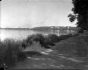
| Date: | 1926 |
|---|---|
| Description: | Lake Mendota, including Fraternity Row and east side shoreline, taken from the lake path on University Bay Drive. |

| Date: | 1926 |
|---|---|
| Description: | View towards an open-air theatre from University of Wisconsin Observatory Drive. |

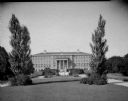
| Date: | 09 12 1926 |
|---|---|
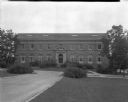
| Description: | University of Wisconsin, Agriculture Hall, 1450 Linden Drive. |
| Date: | 09 12 1926 |
|---|---|
| Description: | University of Wisconsin Agriculture Hall, at 1450 Linden Drive. |

| Date: | 06 30 1926 |
|---|---|
| Description: | View across Observatory Drive, looking down towards the Van Hise dormitories: Adams, Tripp, and Carson Gulley Commons. Picnic Point is in the distance on L... |
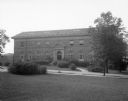
| Date: | 08 09 1926 |
|---|---|
| Description: | Horticulture building at the University of Wisconsin on 1575 Linden Drive. |
| Date: | 08 09 1926 |
|---|---|
| Description: | Horticulture building at the University of Wisconsin at 1575 Linden Drive. |

| Date: | 1927 |
|---|---|
| Description: | Color map, hand-drawn with comic figures engaged in various activities throughout map. Bordered by the river on the left and Lake Michigan on the right, in... |
| Date: | 1922 |
|---|---|
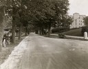
| Description: | View of tree-lined Linden Drive includes parked motorcycles and automobiles on the University of Wisconsin campus. |
If you didn't find the material you searched for, our Library Reference Staff can help.
Call our reference desk at 608-264-6535 or email us at: