 Filter: Subject of roundhouses (railroads)
Filter: Subject of water
Filter: Subject of roundhouses (railroads)
Filter: Subject of water

| Date: | 1908 |
|---|---|
| Description: | A panoramic aerial view of the Isthmus taken from a kite. Lake Mendota is to the right in the background with Picnic Point jutting into the lake. The photo... |
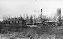
| Date: | 1909 |
|---|---|
| Description: | The Soo line roundhouse. Caption reads: "Soo Round House, Abbottsford, Wis." |
| Date: | 1935 |
|---|---|
| Description: | View down road towards boats docked at the fishing wharf at Ephraim in Door County. The bluff on the horizon is in Peninsula State Park. |
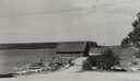
| Date: | 1930 |
|---|---|
| Description: | This map shows types of roadways, cities, lakes, rivers, county boundaries and points of interest. Included are portions of Minnesota, Iowa, Illinois, and ... |

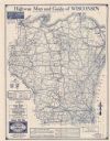
| Date: | 1967 |
|---|---|
| Description: | Air view looking north toward Lake Mendota. The intersection of West Washington Ave. and S. Park Street is at bottom center. The Triangle Redevelopment Pro... |

| Date: | |
|---|---|
| Description: | Aerial view of the Greenbush neighborhood in winter partially demolished for the Triangle Redevelopment Project. Monona Bay and Brittingham park are at rig... |
If you didn't find the material you searched for, our Library Reference Staff can help.
Call our reference desk at 608-264-6535 or email us at:
