 Filter: Subject of school buildings
Filter: Subject of food industry and trade
Filter: Subject of school buildings
Filter: Subject of food industry and trade
| Date: | 11 16 1956 |
|---|---|
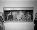
| Description: | Seven boys and one teacher from Cherokee Heights School at the refreshment counter at a school dance. Four of the boys, Jerry Meulenberg, Douglas Green, Mi... |

| Date: | 11 16 1956 |
|---|---|
| Description: | Four students, Kris Roisum, Karen Nelson, Charles Leveque, and Rick Radder, drinking sodas and chatting with Principal Emery Bainbridge at a Cherokee Heigh... |
| Date: | 1939 |
|---|---|
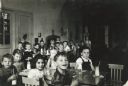
| Description: | A view of young students at Lincoln School sitting around tables and drinking milk out of glass bottles. Behind the students in the background a fireplace ... |
| Date: | 1939 |
|---|---|
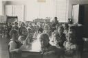
| Description: | A view of young students at Lincoln School clustered around a long table and drinking milk out of glass bottles. In the background two art easels and plant... |
| Date: | 1908 |
|---|---|
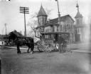
| Description: | Joseph Pearson, milkman, poses with his wagon and team of horses in front of the Madison High School at the corner of Wisconsin Avenue and Johnson Street. |

| Date: | 1905 |
|---|---|
| Description: | This early 20th century map of Door County, Wisconsin, shows the township and range grid, towns, sections, cities and villages, landownership and acreages,... |

| Date: | 1901 |
|---|---|
| Description: | Map shows lakes, rivers, schools, saw mills, post offices, creameries, and churches. Includes significant manuscript annotations showing township divisions... |

| Date: | 1900 |
|---|---|
| Description: | Shows lands belonging to Wisconsin Timber and Land Co., towns, post offices, saw mills, creameries, camps, churches, schools, farm houses, town halls, rail... |

| Date: | 1928 |
|---|---|
| Description: | Shows different types of roads, railroads, schools, churches, farmsteads, cheese factories, mine shafts, old surface workings, streams, old sulphur pits, a... |

| Date: | 05 1958 |
|---|---|
| Description: | Photocopy of a map created by the City of Milwaukee Master Plan Program City Planning Division in May of 1958 representing 1870 "THE CENTRAL AREA OF THE CI... |
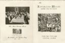
| Date: | 1954 |
|---|---|
| Description: | Back and front of a small folded card menu, with an etching of a quarter view of the exterior of Republican House surrounded by leafy trees on the front co... |

| Date: | 1908 |
|---|---|
| Description: | Map shows townships and sections, landownership and acreages, rural routes, roads, railroads, creameries, churches, schools, and town halls. Sections appea... |

| Date: | 1901 |
|---|---|
| Description: | Map shows townships, schools, creameries, post offices, and roads. The left side of the map features a legend with symbols for points of interest. |

| Date: | 1914 |
|---|---|
| Description: | Map shows townships, schools, creameries, post offices, and roads. The left side of the map features a legend with symbols for points of interest. |

| Date: | |
|---|---|
| Description: | Four men pose on and around a crude wooden platform set up in front of the Winnebago County School of Agriculture and Domestic Economy. There is a barrel o... |

| Date: | 1910 |
|---|---|
| Description: | Slightly elevated view of crowd standing closely around a platform on which a man wearing an apron stands next to a cow. A barrel and wooden pail are also ... |
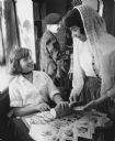
| Date: | 01 16 1962 |
|---|---|
| Description: | Three students at folk fair. One student is sitting at a table slicing bread, with a student standing next to her who is holding a sausage on a plate. A th... |
If you didn't find the material you searched for, our Library Reference Staff can help.
Call our reference desk at 608-264-6535 or email us at:
