 Filter: Subject of science
Filter: Subject of coasts
Filter: Subject of science
Filter: Subject of coasts

| Date: | 1786 |
|---|---|
| Description: | One half of a four sheet nautical chart, showing the coastlines of the north-west hemisphere. The interior lands are left bare, even of basic features such... |

| Date: | 1775 |
|---|---|
| Description: | This map shows the northern Pacific Ocean along with north eastern Asia and western North America. The interior of Asia contains detailed engravings of pla... |

| Date: | 1788 |
|---|---|
| Description: | This map shows the north western coast of North America, including the southern coast of what will be Alaska and parts of the Aleutian Islands. It includes... |

| Date: | 1766 |
|---|---|
| Description: | Map representing the northern Pacific Ocean along with north eastern Asia and western North America. The interior of Asia contains very detailed engravings... |

| Date: | 1772 |
|---|---|
| Description: | Map of the north west portion of America and Canada, as well as a small section of eastern Russia. Lakes, rivers, Native American land and the occasional ... |

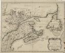
| Date: | 1759 |
|---|---|
| Description: | Map of north eastern Canada and parts of New England, showing settlements, cities, portages, Native American land, mountains, lakes, and rivers. The unusua... |
| Date: | 1755 |
|---|---|
| Description: | Bellin's landmark map of eastern Canada and part of northeast America extending from Newfoundland to the borders of Lake Ontario and south to Cape Cod. The... |
If you didn't find the material you searched for, our Library Reference Staff can help.
Call our reference desk at 608-264-6535 or email us at: