 Filter: Subject of science
Filter: Subject of mines and mineral resources
Filter: Subject of science
Filter: Subject of mines and mineral resources
| Date: | 11 12 2013 |
|---|---|
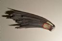
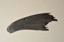
| Description: | A hematite fan, approximately six inches in length, from the mineral collection of Ferdinand Hotz at the University of Wisconsin Geology Museum. This speci... |
| Date: | 11 12 2013 |
|---|---|
| Description: | A hematite fan, approximately six inches in length, from the mineral collection of Ferdinand Hotz at the University of Wisconsin Geology Museum. This speci... |
| Date: | 11 12 2013 |
|---|---|
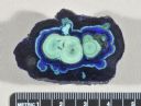
| Description: | A cut and polished azurite malachite nodule from the mineral collection of Ferdinand Hotz at the University of Wisconsin Geology Museum. Azurite and malach... |
| Date: | 11 12 2013 |
|---|---|
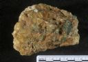
| Description: | A specimen of emerald in matrix from the mineral collection of Ferdinand Hotz at the University of Wisconsin Geology Museum. |
| Date: | 11 12 2013 |
|---|---|
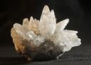
| Description: | A dogtooth calcite specimen from the mineral collection of Ferdinand Hotz at the University of Wisconsin Geology Museum. The specimen is approximately thre... |

| Date: | 1783 |
|---|---|
| Description: | This map is hand-colored and shows the boundaries of British, Spanish, and the newly recognized American claims, as well as the fishing rights granted to F... |

| Date: | 1720 |
|---|---|
| Description: | Map of North America from from the Rio Grande to the Atlantic Ocean, showing boundaries, the colonies, cities, settlements, mines, forts, Native American l... |

| Date: | 1720 |
|---|---|
| Description: | Detailed, ornate, and comprehensive map of America from the east coast to present day Texas. Numerous features appear throughout the map, including Native ... |

| Date: | 1782 |
|---|---|
| Description: | Map of America covering the Rio Grande to the Atlantic Ocean, showing boundaries, the colonies, cities, settlements, Native American lands and villages, m... |
If you didn't find the material you searched for, our Library Reference Staff can help.
Call our reference desk at 608-264-6535 or email us at: