 Filter: Subject of service industries
Filter: Subject of mississippi river
Filter: Subject of service industries
Filter: Subject of mississippi river

| Date: | 1880 |
|---|---|
| Description: | Bird's-eye map over the Mississippi River of Fountain City. Paddle steamers and steamboats are on the river, and bluffs are in the background. |

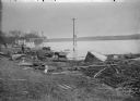
| Date: | 04 22 1965 |
|---|---|
| Description: | A panoramic view of the Mississippi River flooding during the spring, showing the dykes built along the Chicago, Burlington & Quincy Railroad tracks at Sec... |

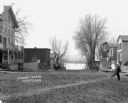
| Date: | 1895 |
|---|---|
| Description: | View down road with the Bay State House on the left. Three houses and a barbershop also line the street. A lamppost is in the left foreground. The Mississ... |

| Date: | 1898 |
|---|---|
| Description: | Shows railway lines in Wisconsin marked in red and counties in colors. The meridians are Greenwich, Wisconsin and Washington, Wisconsin. The map folds into... |
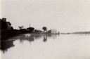
| Date: | 1931 |
|---|---|
| Description: | Mississippi River from the Brisbois Mansion. Left to right: Dousman House Hotel, railroad station, electrical plant smokestack, Diamond Jo warehouse, and a... |
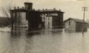
| Date: | 1916 |
|---|---|
| Description: | Dousman House hotel, surrounded by Mississippi River flood water in spring. View looking northwest. |

| Date: | 1900 |
|---|---|
| Description: | The Dousman House as seen from the Mississippi River. Caption reads: "Dousman House, East Bank of Mississippi River, Prairie Du Chien, Wis." |
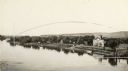
| Date: | 1900 |
|---|---|
| Description: | The Dousman Hotel seen from an elevated view of the Mississippi River. |

| Date: | |
|---|---|
| Description: | Map reads: "Historic and Scenic Wisconsin — Land of Gathering Waters." In an inset there is a hand-painted depiction of the Wisconsin State Seal. For some ... |

| Date: | |
|---|---|
| Description: | Map of Baraboo and its surroundings, showing the ancient mound city, the water power, and thoroughfares, drawn by William H. Canfield. Canfield includes sk... |
| Date: | |
|---|---|
| Description: | A blurred image of a man as he is walking across the unpaved street which goes down to the Mississippi River. The Bay State House and more storefronts are ... |

| Date: | 1930 |
|---|---|
| Description: | Pen and ink map on paper of Wisconsin and northern Illinois showing stagecoach routes (marked in red) that traveled between Lake Michigan and the Mississip... |

| Date: | 1856 |
|---|---|
| Description: | A hand-colored map of Wisconsin, showing the county boundaries, towns, cities, railroads, roads, lakes, rivers, bays, and the Lake Superior’s islands. In ... |
| Date: | 1910 |
|---|---|
| Description: | View along shoreline of man examining a rowboat while crouching in the water wearing boots. Behind him is a ferry. There are several men on the shore watch... |

| Date: | 1915 |
|---|---|
| Description: | A map showing the location of post offices in Wisconsin and Michigan that were in operation as of April, 1915, along with the mail routes in use as well as... |

| Date: | 1937 |
|---|---|
| Description: | This map shows the Wisconsin Conservation Department forest protection divisions and the locations of state forests, national forests, Indian reservations,... |

| Date: | 05 01 1938 |
|---|---|
| Description: | This map shows the locations of Wisconsin Conservation Department forest protection districts and cooperative areas, state forests, national forests, India... |

| Date: | 1950 |
|---|---|
| Description: | This road map shows federal, state and county roads in Wisconsin, northern Illinois, northeastern Iowa, eastern Minnesota, and the western portion of Michi... |

| Date: | 1969 |
|---|---|
| Description: | This Post Office Department map identifies post offices, summer post offices, rural stations, highway post offices, Post Office sectional centers, rural de... |

| Date: | 1857 |
|---|---|
| Description: | This map depicts the township survey grid in Wisconsin and northern Michigan and identifies counties, named towns, cities and villages, rivers, lakes, rail... |
If you didn't find the material you searched for, our Library Reference Staff can help.
Call our reference desk at 608-264-6535 or email us at: