 Filter: Subject of shipping
Filter: Subject of mississippi river
Filter: Subject of shipping
Filter: Subject of mississippi river

| Date: | 1873 |
|---|---|
| Description: | Bird's-eye map of La Crosse from the Mississippi River. |
| Date: | |
|---|---|
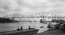
| Description: | View of two bridges on the Mississippi River and the working river banks. A number of boats are in the water and cargo is stacked on the shore. |
| Date: | |
|---|---|
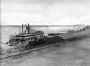
| Description: | Elevated view of the steamboat "Bald Eagle" unloading on the riverfront. "Bald Eagle" is painted on the top of the ship. Several men are working on and nea... |

| Date: | 1858 |
|---|---|
| Description: | This map shows the proposed railways of the Tomah & Lake St. Croix Railroad (from Tomah to Hudson) and the St. Croix & Lake Superior Railroad (from Hudson ... |

| Date: | 1924 |
|---|---|
| Description: | This map shows railroads, electric lines, and steamship lines. The left margin includes an index of principal cities, and the lower left corner includes a... |

| Date: | 1868 |
|---|---|
| Description: | This map includes a table of estimated costs "by Brev. Maj. Gen. G.K. Warren Maj. U.S.E., of improvement of Wis. River from his survey of 1867." Included a... |
| Date: | 08 1940 |
|---|---|
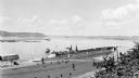
| Description: | Elevated view of a coal barge pushed by a stern wheeled steamboat heading upstream from the Mississippi River Lock and Dam No. 9 north of Prairie du Chien,... |
If you didn't find the material you searched for, our Library Reference Staff can help.
Call our reference desk at 608-264-6535 or email us at: