 Filter: Subject of signs and symbols
Filter: Subject of coasts
Filter: Subject of signs and symbols
Filter: Subject of coasts
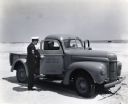
| Date: | 1943 |
|---|---|
| Description: | Two uniformed men sit inside an International K-1 U.S. Coast Guard truck parked on a beach while another man speaks to them through the open passenger door... |

| Date: | 1937 |
|---|---|
| Description: | A pictorial, hydrographic map shows sailing courses, historical and contemporary coastal attractions, roads, and the contour depths of Green Lake, Wisconsi... |
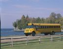
| Date: | 1990 |
|---|---|
| Description: | Color photo of an International school bus driven along a coastal road. In the foreground is a split-rail fence and lawn. The photograph was probably taken... |

| Date: | 1667 |
|---|---|
| Description: | Map of Virginia depicting the discoveries detailed by John Smith in his exploration of the region. It shows Jamestown, Native American tribes and villages,... |

| Date: | 1671 |
|---|---|
| Description: | Map of Virginia depicting the discoveries detailed by John Smith in his exploration of the region. It shows Jamestown, Native American tribes and villages,... |
If you didn't find the material you searched for, our Library Reference Staff can help.
Call our reference desk at 608-264-6535 or email us at: