 Filter: Subject of student housing
Filter: Subject of transportation
Filter: Subject of water
Filter: Subject of student housing
Filter: Subject of transportation
Filter: Subject of water
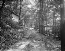
| Date: | 06 27 1931 |
|---|---|
| Description: | Path, "main street," through the woods at the University of Wisconsin Tent Colony. Also known as Camp Gallistella on the south shore of Lake Mendota, west ... |

| Date: | 06 30 1926 |
|---|---|
| Description: | View across Observatory Drive, looking down towards the Van Hise dormitories: Adams, Tripp, and Carson Gulley Commons. Picnic Point is in the distance on L... |
| Date: | 1926 |
|---|---|
| Description: | View of Adams, Tripp and Van Hise Halls. All are residence halls on the University of Wisconsin campus with Picnic Point and Lake Mendota in the backgroun... |
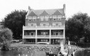
| Date: | 1915 |
|---|---|
| Description: | Exterior front view from Lake Mendota of the Delta Upsilon Fraternity House, located at 640 North Francis Street, erected in 1906. A group of people are o... |

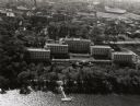
| Date: | 1956 |
|---|---|
| Description: | Aerial view looking east along Madison's Lake Mendota shoreline. The large building under construction at center is Carroll Hall, a University of Wisconsin... |

| Date: | 1947 |
|---|---|
| Description: | University of Wisconsin-Madison, from Park Street to the men's dormitories. Part of Lake Mendota is in the top right corner. |

| Date: | 1946 |
|---|---|
| Description: | University of Wisconsin-Madison campus on isthmus, including the Agricultural campus and men's dormitories. Part of Lake Mendota is in the top right corner... |
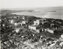
| Date: | 1924 |
|---|---|
| Description: | University of Wisconsin-Madison lower campus and the surrounding neighborhoods. Lake Mendota and Picnic Point are in the background. |
| Date: | 1924 |
|---|---|
| Description: | University of Wisconsin-Madison aerial view overlooking the lower campus and surrounding neighborhoods. Lake Mendota and Picnic Point are in the background... |

| Date: | 1946 |
|---|---|
| Description: | University of Wisconsin-Madison campus, looking south from Lake Mendota. Camp Randall stadium is in the upper right. |

| Date: | 1956 |
|---|---|
| Description: | Aerial view over University Avenue of the University of Wisconsin-Madison campus, including University farm in the upper middle. The shoreline of Lake Mend... |
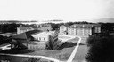
| Date: | 1947 |
|---|---|
| Description: | Aerial view of the Elizabeth Waters women's dormitory on the University of Wisconsin-Madison campus. In the upper right corner is Camp Randall. A long pier... |

| Date: | 1948 |
|---|---|
| Description: | Aerial view of the Elizabeth Waters women's dormitory on the University of Wisconsin-Madison campus. The dorm is also referred to as "Liz" or "The Rock". A... |
| Date: | 1903 |
|---|---|
| Description: | View from Lake Mendota of house at 630 N. Lake Street. Robert C. Spencer, architect. The Armory and University of Wisconsin-Madison Boathouse are behind an... |

| Date: | 08 17 1927 |
|---|---|
| Description: | Elevated view of dormitories on the University of Wisconsin-Madison campus. Adams, Van Hise and Tripp Halls with Lake Mendota in the background. Picnic Poi... |

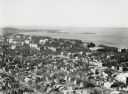
| Date: | 1929 |
|---|---|
| Description: | Elevated panoramic view towards the northeast from the tower of the Congregational Church of the University of Wisconsin-Madison campus, with Lake Mendota ... |

| Date: | 1942 |
|---|---|
| Description: | A detail of a Madison Sanborn map, including Lakelawn Place. |
If you didn't find the material you searched for, our Library Reference Staff can help.
Call our reference desk at 608-264-6535 or email us at: