 Filter: Subject of superior, lake
Filter: Community of Bayfield
Filter: Subject of superior, lake
Filter: Community of Bayfield

| Date: | 1856 |
|---|---|
| Description: | This map shows land ownership by name, a plat of Bayfield, local streets, part of Lake Superior, part of Madeline Island, and part of Bass Island. La Point... |

| Date: | 07 2001 |
|---|---|
| Description: | David Obey poses with Park Ranger Geoffrey Smith on the left and Martin Hanson on the right. They are standing on the beach with water and land in the back... |

| Date: | |
|---|---|
| Description: | Three women stand on the shore in front of the steamer Barker at Devils Island natural dock. |
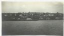
| Date: | 1916 |
|---|---|
| Description: | View across Lake Superior towards Bayfield. |

| Date: | 2000 |
|---|---|
| Description: | This map shows national parks, county and state forests, Indian reservations, municipal land, private land, docks, boat access, camping, and points of inte... |
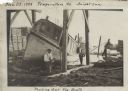
| Date: | 11 29 1908 |
|---|---|
| Description: | Men working on pulling the boat "Fish Hawk" out of the water. One man is kneeling in front of the boat and looking at the camera. A man in the background i... |
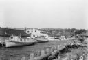
| Date: | 07 1936 |
|---|---|
| Description: | Fishing tugs are moored alongside the wharf at Bayfield. The large Bayfield Fish Co. building is identified in large letters on the end of the building. Th... |
If you didn't find the material you searched for, our Library Reference Staff can help.
Call our reference desk at 608-264-6535 or email us at: