 Filter: Subject of superior, lake
Filter: County of Ashland
Filter: Subject of superior, lake
Filter: County of Ashland

| Date: | 1938 |
|---|---|
| Description: | View of a house on Nebraska Row on Madeline Island. In the foreground is a flag pole, bench, path, lawn and trees. On the left are docks from the lake shor... |

| Date: | |
|---|---|
| Description: | Aerial view of town, showing the shoreline of Lake Superior, ore docks, roads, houses, buildings, trees, and smokestacks. Text describing this photograph s... |

| Date: | 1907 |
|---|---|
| Description: | A map of the eastern portion of the Apostle Islands group, and a detailed map of Gull Island showing the relief on the island, are included here, along wit... |

| Date: | 1834 |
|---|---|
| Description: | This copy of an 1834 map in the American Fur Company's papers held by the New-York Historical Society shows an outline of Chequamegon Bay and Madeline Isla... |

| Date: | 1956 |
|---|---|
| Description: | This map shows the types of upland and lowland forest vegetation on Stockton Island, one of the Apostle Islands in Lake Superior. |

| Date: | 1977 |
|---|---|
| Description: | This pictorial map was produced by the Chateau, a resort in La Pointe, and shows Madeline Island landmarks and tourist attractions. On the verso is the spr... |

| Date: | 1990 |
|---|---|
| Description: | This tourism brochure of Ashland County, Wisconsin, from the Ashland Area Chamber of Commerce includes a map of the county showing tourist destinations and... |

| Date: | 1900 |
|---|---|
| Description: | This chart of the northern Apostle Islands and Lake Superior shoreline shows relief by contours and spot heights and depths by contours, gradient tints and... |

| Date: | 1964 |
|---|---|
| Description: | This 1964 map of Madeline Island, Ashland County, Wisconsin, shows existing and historical locations, roads, the boundaries of a proposed state park, secti... |

| Date: | 1988 |
|---|---|
| Description: | Congressman David Obey and his wife Joan on Martin Hanson's pontoon. He was a good friend of the Obeys and was inducted into the Wisconsin Conservation Hal... |

| Date: | 06 1923 |
|---|---|
| Description: | Sanborn map of Ashland, which includes Chequamegon Bay. |
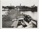
| Date: | 09 14 1962 |
|---|---|
| Description: | View from pier, lined with rocks, towards town. There are industrial buildings along the shoreline, and up a small rise is a building with a tower, and on ... |
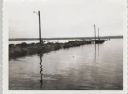
| Date: | 09 14 1962 |
|---|---|
| Description: | View across water towards jetty and dock, with three lampposts, from south east. |
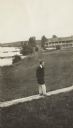
| Date: | 1913 |
|---|---|
| Description: | Jesse Stone walking on board sidewalk, with the Mission Inn along the shoreline in the background. |
| Date: | 1920 |
|---|---|
| Description: | View of Mrs. Cora Hull and Mrs. Julia Wood sitting on the beach at a shoreline. A man stands near the water. In the background are trees. |
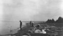
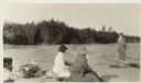
| Date: | 08 22 1916 |
|---|---|
| Description: | View along shoreline towards people at a Bear Island picnic. A man stands near the water, and two women and a another man are among the logs along the shor... |

| Date: | 1910 |
|---|---|
| Description: | This map shows the locations of school houses, farms, roads, railroads, and Bad River Indian Reservation. Relief is shown by hachures. Yellow and red manus... |

| Date: | |
|---|---|
| Description: | Two women and a man are walking down the dock near a boat named "Chippewa" on Rocky Island.c South Twin Island is across the water in the background. |

| Date: | 08 1971 |
|---|---|
| Description: | Aerial view of Madeline Island, and a few of the Apostle Islands in the distance. |
If you didn't find the material you searched for, our Library Reference Staff can help.
Call our reference desk at 608-264-6535 or email us at:
