 Filter: Subject of superior, lake
Filter: County of Douglas
Filter: Subject of superior, lake
Filter: County of Douglas

| Date: | 1915 |
|---|---|
| Description: | Elevated view of the harbor. Caption reads: "The Harbor, Superior, Wis." |

| Date: | 1910 |
|---|---|
| Description: | Caption reads: "The Great Northern. One of the largest Elevators in the World, Superior, Wis." |

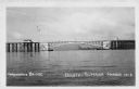
| Date: | 1961 |
|---|---|
| Description: | Aerial view of the Duluth-Superior bridge. |
| Date: | 1940 |
|---|---|
| Description: | View of the Arrowhead Bridge at the Duluth-Superior Harbor. |

| Date: | 1960 |
|---|---|
| Description: | Aerial view with docks in the foreground. Caption reads: "Superior, Wisconsin." |

| Date: | 1891 |
|---|---|
| Description: | Photograph of a painting by May Conniff Frost showing the tugboat Record of the Inman Line pulling a lake schooner through rough waters into Superio... |

| Date: | 1911 |
|---|---|
| Description: | This map, taken from the 1911 Map of Wisconsin showing geology and roads by Hotchkiss and Thwaites, shows the northwest portion of Douglas County, Wisconsi... |

| Date: | 1953 |
|---|---|
| Description: | This is a detailed map of Douglas County, Wisconsin, showing townships and township borders, numbered wards, roadways, and bodies of water. There are annot... |

| Date: | 1896 |
|---|---|
| Description: | This 1896 map of Douglas County, Wisconsin, shows the township and range grid, the towns of Superior, Brule, Gordon, and Nebagamain, sections, cities and v... |

| Date: | 11 26 1907 |
|---|---|
| Description: | Relief shown by hachures. Shows roads, railroads, schools, post offices, rivers, and lakes of Douglas County, and portions of Minnesota and Lake Superior. ... |

| Date: | 1930 |
|---|---|
| Description: | Shows county system of roads which are surfaced, well graded, common, or unimproved, town roads, state trunk highways, town and village boundaries, schools... |

| Date: | 1929 |
|---|---|
| Description: | "Compliments of the Douglas County Highway Department"--Top margin. Shows state-trunk highways, county highways, town roads, trails, boundaries, and concr... |

| Date: | 1953 |
|---|---|
| Description: | "Compliments of the Douglas County Highway Department"--Top margin. Shows federal highways, state trunk highways, county highways, town roads, unimproved ... |

| Date: | 1930 |
|---|---|
| Description: | Shows county system of roads which are surfaced, well graded, common, or unimproved, town roads, state trunk highways, town and village boundaries, schools... |

| Date: | 1890 |
|---|---|
| Description: | This map of Superior shows labeled streets, railroads, docks, city wards, and the state line. Relief is shown by hachures. Below the title reads: "Bedford ... |

| Date: | 1890 |
|---|---|
| Description: | This map of Superior shows city wards, bays, docks, some businesses and points of interest. Relief is shown by hachures. The back of the map features a typ... |

| Date: | 1898 |
|---|---|
| Description: | This map of Superior shows city wards, bays, docks, and some businesses and points of interest. Relief is shown by hachures. The map probably came from a C... |

| Date: | 1898 |
|---|---|
| Description: | This map of Duluth and Superior show lands that "will be for sale soon" in portions of Douglas County, Wisconsin and Saint Louis County, Minnesota. The map... |

| Date: | 1907 |
|---|---|
| Description: | This map of Superior and the vicinity shows selected company properties, railroads, and roads in a portion of Douglas County. The map reads: "Copyrighted 1... |

| Date: | 1909 |
|---|---|
| Description: | This map of Duluth and Superior was issued by the Duluth Street Railway Company and shows street railway routes in the cities, as well as lakes, bays, harb... |
If you didn't find the material you searched for, our Library Reference Staff can help.
Call our reference desk at 608-264-6535 or email us at: