 Filter: Subject of superior, lake
Filter: Subject of intellectual life
Filter: Community of Superior
Filter: Subject of superior, lake
Filter: Subject of intellectual life
Filter: Community of Superior

| Date: | 1883 |
|---|---|
| Description: | Bird's-eye map of Superior, county seat of Douglas County, on the shores of Lake Superior, with insets of points of interest. |

| Date: | 1915 |
|---|---|
| Description: | Bird's-eye view of Superior, Wisconsin, and Duluth, Minnesota on opposite shore of Lake Superior. |

| Date: | 1887 |
|---|---|
| Description: | Bird's-eye view of Superior, on Lake Superior. |

| Date: | 1890 |
|---|---|
| Description: | Bird's-eye map of West Superior and Superior, with insets of Wright Farm and First Building in Superior. |

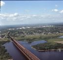
| Date: | 1961 |
|---|---|
| Description: | Aerial view of the Duluth-Superior bridge. |

| Date: | 1960 |
|---|---|
| Description: | Aerial view with docks in the foreground. Caption reads: "Superior, Wisconsin." |

| Date: | |
|---|---|
| Description: | Aerial view of harbor, with shipyards in the foreground and Superior in the background. Caption reads: "Aerial View of Harbor, Superior, Wisconsin." |
| Date: | 08 1971 |
|---|---|
| Description: | Aerial view of an ore dock next to Hog Island. The town is in the distance. In the far background are the white storage buildings of the oil refinery. |
If you didn't find the material you searched for, our Library Reference Staff can help.
Call our reference desk at 608-264-6535 or email us at: