 Filter: Subject of superior, lake
Filter: Subject of transportation
Filter: Subject of superior, lake
Filter: Subject of transportation
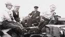
| Date: | 1910 |
|---|---|
| Description: | Four men aboard the "Lucy" on Lake Superior. Andrew Siem is the boat owner and is operating the tiller. Man with moustache identified as N.J. Ross. |
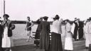
| Date: | 1910 |
|---|---|
| Description: | Group of ladies on Mission Dock, and "Ollie" Wilson in bathing suit walking by. Ladies identified as Mrs. N.J. Ross (shielding eyes) and Loretta Salmon in ... |

| Date: | |
|---|---|
| Description: | Seven girls lined up on Madeline Island Dock. |

| Date: | 1930 |
|---|---|
| Description: | Large group of fishermen standing on ice with catch of fish displayed on airplane wing near La Pointe, Madeline Island. |
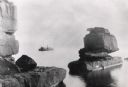
| Date: | 1898 |
|---|---|
| Description: | Rock formation, The Sphinx, on Stockton Island of the Apostle Islands. Steamer "Edna" in background on Lake Superior. |

| Date: | 1861 |
|---|---|
| Description: | A map of Wisconsin showing cities, counties, major roads, railroads, and bodies of water. Includes an inset of the vicinity of Milwaukee. |

| Date: | 1872 |
|---|---|
| Description: | Map entitled Office Wallbridge Bro. U. Sargent showing upper Minnesota and Wisconsin, as well as Lake Superior. |

| Date: | 1851 |
|---|---|
| Description: | Map of the Lake Superior region showing the railroad and steamboat connection. |

| Date: | 1858 |
|---|---|
| Description: | Map of the Lake Superior region showing the railroad and steamboat connections. |
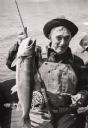
| Date: | |
|---|---|
| Description: | A fisherman sitting in a boat is holding a cigar and posing with lake trout. |
| Date: | 1955 |
|---|---|
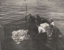
| Description: | Three fisherman in a boat pulling in a net full of fish on Chequamegon Bay while a man and a boy look on. |
| Date: | 1955 |
|---|---|
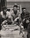
| Description: | Catch of lake trout displayed by three fisherman on the pier at Little Sand Bay. From left to right are Martin Johnson, Hermy Johnson, and Myron Lohman. |
| Date: | |
|---|---|
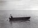
| Description: | Lone man boating or fishing alone on Lake Superior. He is standing at the rear of the boat holding an oar. |

| Date: | 1890 |
|---|---|
| Description: | This map shows lakes, railroads, and rivers. An explanation of railroad lines with mileage in Wisconsin and total mileage for 1890 is included. Portions of... |
| Date: | 1938 |
|---|---|
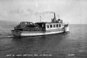
| Description: | A car ferry transporting a car on Lake Superior between LaPointe, Madeline Island, and Bayfield. Two men are sitting on a bench near the car, and a shoreli... |
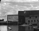
| Date: | 1969 |
|---|---|
| Description: | View from water of the sides of three wharf buildings in a bay of Lake Superior. |
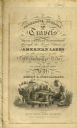
| Date: | 1820 |
|---|---|
| Description: | Narrative Journal of Travels from Detroit Northwest through the Great chain of American Lakes to the sources of the Mississippi River in the year 1820. Ill... |
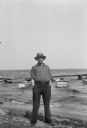
| Date: | 1931 |
|---|---|
| Description: | Albert Hansen by Lake Superior at Manitoulin Island. |

| Date: | 1884 |
|---|---|
| Description: | The official railroad map of Wisconsin showing railroad lines throughout the state. |

| Date: | 1878 |
|---|---|
| Description: | A color map detailing Ashland and Bayfield counties, including Lake Superior and the Apostle Islands. |
If you didn't find the material you searched for, our Library Reference Staff can help.
Call our reference desk at 608-264-6535 or email us at: