 Filter: Subject of superior, lake
Filter: Subject of transportation
Filter: Subject of superior, lake
Filter: Subject of transportation

| Date: | 1856 |
|---|---|
| Description: | This map shows the entire state of Wisconsin with counties, cities and rivers. It includes an inset of the layout of the streets of Milwaukee and a chart w... |

| Date: | 1857 |
|---|---|
| Description: | This detailed map was drawn nearly a decade after Wisconsin entered statehood. It depicts the entire state, northern Illinois and part of the upper peninsu... |

| Date: | 1860 |
|---|---|
| Description: | A map of Wisconsin showing the railroads, rivers, counties, cities, villages, and named towns in the state, as well as the township grid for the portion of... |

| Date: | 1939 |
|---|---|
| Description: | This map shows the towns to Gingles, Sanborn, and Guney as well as Chequamegon Bay, Kakagon River, White River, Marengo River, Bad River, Potato River, Vau... |
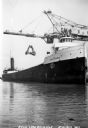
| Date: | 1930 |
|---|---|
| Description: | View of the ship "Alex B. Uhrig" in the process of coal unloading on the Reiss Coal Dock No. 2. |

| Date: | 1935 |
|---|---|
| Description: | View of the Ashland Band Shell with benches, trees, and what is today Highway 2 in the foreground. On the left is a large metal tower, and in the backgroun... |

| Date: | 1866 |
|---|---|
| Description: | This thematic shows the effects that Lake Michigan has had on Wisconsin mean temperatures in January and July. The map shows counties, some cities, rivers ... |

| Date: | 1938 |
|---|---|
| Description: | View of a house on Nebraska Row on Madeline Island. In the foreground is a flag pole, bench, path, lawn and trees. On the left are docks from the lake shor... |

| Date: | 1935 |
|---|---|
| Description: | View of two men sitting in rattan chairs under a roof on the deck of a boat. They are both wearing dress shirts and ties. One man is wearing a hat, and the... |

| Date: | 1916 |
|---|---|
| Description: | A pen on paper, hand-drawn map that shows the railroads, rivers, county outlines, and cities and villages in Wisconsin, northern Illinois, and the western ... |

| Date: | 1866 |
|---|---|
| Description: | A pen on paper, hand-drawn and colored map of Wisconsin and Michigan, showing counties, cities and villages, rivers and lakes, as well as railroads are in ... |

| Date: | 1866 |
|---|---|
| Description: | A pen on paper, hand-drawn and colored map of Wisconsin and Michigan, showing counties, cities and villages, rivers and lakes, as well as railroads are in ... |

| Date: | 1867 |
|---|---|
| Description: | Map of the entire state indicates county boundaries outlined in red, cities of over 3000 inhabitants and county seats. It also marks rivers and lakes. |

| Date: | 1868 |
|---|---|
| Description: | This map of the entire state shows county boundaries outlined in red, cities of over 3000 inhabitants and county seats. It also marks rivers, lakes, railro... |

| Date: | 1868 |
|---|---|
| Description: | Prepared for the State Board of Emigration in 1868, this map shows county boundaries, some cities, and completed and projected railroads. |

| Date: | 1870 |
|---|---|
| Description: | A geological survey map of Wisconsin, with hand-colored portions showing the surveys completed from 1873 to 1875. Although the title and legend are in Wel... |

| Date: | 1870 |
|---|---|
| Description: | Map of Wisconsin showing counties and their county seats, towns and cities with over 3,000 inhabitants, the Detroit and Milwaukee Steam Ship Line, and both... |

| Date: | 1871 |
|---|---|
| Description: | A map of Wisconsin which shows the counties, county seats, those cities with over 3,000 inhabitants. The map also depicts the rivers, lakes, completed and ... |

| Date: | 1872 |
|---|---|
| Description: | A map of Wisconsin which shows the counties, county seats, those cities with over 3,000 inhabitants. The map also displays the rivers, lakes, completed and... |
| Date: | 1873 |
|---|---|
| Description: | A map of Wisconsin along with southeastern Minnesota and Iowa, northern Illinois and the Upper Peninsula of Michigan, showing the counties, county seats, v... |
If you didn't find the material you searched for, our Library Reference Staff can help.
Call our reference desk at 608-264-6535 or email us at: