Filter: Subject of superior, lake
Filter: Subject of transportation
Filter: Subject of superior, lake
Filter: Subject of transportation

| Date: | 1910 |
|---|---|
| Description: | Bird's-eye view looking east, with Washburn Harbor at center and Chequamegon Bay in Lake Superior covering most of the upper image. Streets with buildings... |

| Date: | 02 26 1887 |
|---|---|
| Description: | Bird's-eye map of Ashland, and the Apostle Islands in Lake Superior. Caption reads: "Ashland and the Apostle Islands." |

| Date: | |
|---|---|
| Description: | Devils Island on Lake Superior, outermost of the Apostle Islands group. There appears to be the edge of a boat in the foreground. |

| Date: | |
|---|---|
| Description: | Looking West from Knight Block, with shipping piers and sailing ships on right side, railroad on left, trees in background. Horse-drawn carriages on street... |

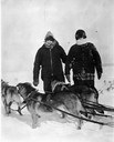
| Date: | 1945 |
|---|---|
| Description: | Mary L. Eldridge, Dick Eldridge, Barney Johnson, and two other people kneeling in front of dog sled on Lake Superior. |

| Date: | 1997 |
|---|---|
| Description: | The steel and reinforced concrete grain elevator built by the Great Northern Railroad at Superior about 1900. This contemporary photograph was taken to acc... |
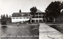
| Date: | 1937 |
|---|---|
| Description: | Old Mission Inn on shoreline of Lake Superior, taken from end of dock. The Old Mission Inn was razed in 1965. |
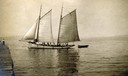
| Date: | 1910 |
|---|---|
| Description: | Gaff-rigged schooner the "Lizzie W." on Lake Superior just off from the mission dock on Madeline Island. |
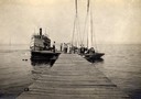
| Date: | 1910 |
|---|---|
| Description: | Steamboat "Skater" and two sailboats at end of the mission dock on Madeline Island. |

| Date: | 1905 |
|---|---|
| Description: | Camp Stella looking south toward the Bayfield County shoreline from an Apostle Island. |

| Date: | 1885 |
|---|---|
| Description: | View of the ore dock of the Milwaukee, Lake Shore, and Western Railroad. Large logs, buildings and a railroad bridge are in the foreground. |

| Date: | 1929 |
|---|---|
| Description: | View of an ore dock on Chequamegon Bay. Buildings on the shore of the bay can be seen, however, not the water. |

| Date: | 1920 |
|---|---|
| Description: | Caption reads: "Mammoth Ore Docks, Ashland, Wis." A building and roads are in the foreground. Several ore ships can be seen. |

| Date: | 1913 |
|---|---|
| Description: | Aerial bridge and harbor, with a large boat passing underneath. A lamppost and a beacon are along the walkway towards the bridge on the left. Caption reads... |

| Date: | 1856 |
|---|---|
| Description: | Wisconsin map illustrating the Mineral Point Railroad and its connections. |

| Date: | 01 04 1862 |
|---|---|
| Description: | Engraving of the city of Superior and Lake Superior, also depicting railroad piers, Minnesota Point, and the steamboat "Star". The engraving appears on a l... |
| Date: | 1870 |
|---|---|
| Description: | One of the etchings published in an atlas of Lake County, Illinios in 1870 by George Ogle. Etchings done by the Wisconsin Central Railroad. |

| Date: | 1844 |
|---|---|
| Description: | Map of Wisconsin including Lakes Michigan and Superior. Inset includes "N.W. Part of Wiskonsan." |
If you didn't find the material you searched for, our Library Reference Staff can help.
Call our reference desk at 608-264-6535 or email us at: