 Filter: Subject of telephone
Filter: Subject of church buildings
Filter: Subject of telephone
Filter: Subject of church buildings
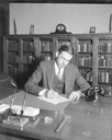
| Date: | 09 26 1935 |
|---|---|
| Description: | Rev. Edwin O. Kennedy sitting at a desk writing a letter, Christ Presbyterian Church, 124 Wisconsin Avenue. There is a telephone on the desk, and books are... |
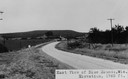
| Date: | |
|---|---|
| Description: | View of rural Blue Mounds, with a two-lane, paved road. The caption at the bottom reads: "East View of Blue Mounds, Wis. Elevation, 1760 ft.". |

| Date: | |
|---|---|
| Description: | A view of houses, with a Christian church in the right foreground. A car is parked in front of the church. Poles with telephone or electric lines are along... |
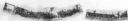
| Date: | 06 1967 |
|---|---|
| Description: | Composite panoramic view of the south side of the 700 block of State Street. Lake Street parking ramp and University of Wisconsin Extension building are vi... |

| Date: | 1943 |
|---|---|
| Description: | A map that shows the lands for sale by the Tomahawk Land Company of Tomahawk, Wisconsin, in the counties of Langlade, Lincoln, Oneida, and Price. The map s... |

| Date: | 03 25 1959 |
|---|---|
| Description: | Four women taking part in a skit at the Madison League of Women Voters convention at the Unitarian Meeting House. Left to right are: Mrs. Mary Newgent, Mrs... |

| Date: | 1935 |
|---|---|
| Description: | This map shows railroads, telephone lines, roads, trails, schools, sub-agency, lookout stations, churches, community centers, and school site and farm. Bil... |

| Date: | 1973 |
|---|---|
| Description: | View across State Street towards the Pres House, a Presbyterian Church. Two phone booths are near the sidewalk in front of the church on the left, with a p... |
If you didn't find the material you searched for, our Library Reference Staff can help.
Call our reference desk at 608-264-6535 or email us at: