 Filter: Subject of telephone
Filter: Subject of roads
Filter: Subject of architecture
Filter: Subject of telephone
Filter: Subject of roads
Filter: Subject of architecture
| Date: | |
|---|---|
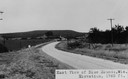
| Description: | View of rural Blue Mounds, with a two-lane, paved road. The caption at the bottom reads: "East View of Blue Mounds, Wis. Elevation, 1760 ft.". |
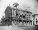
| Date: | 1895 |
|---|---|
| Description: | View from road of the Buena Vista House. There is a utility pole in front with many wires attached. This Greek revival inn was erected in 1843 by Samuel R.... |
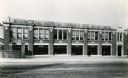
| Date: | 1943 |
|---|---|
| Description: | Exterior of International Harvester's General Office for Great Britain. The building included a showroom, service station, and parts and machine warehouse.... |

| Date: | |
|---|---|
| Description: | A view of houses, with a Christian church in the right foreground. A car is parked in front of the church. Poles with telephone or electric lines are along... |
| Date: | |
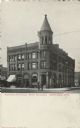
|---|---|
| Description: | Exterior view of the three-story brick National Bank building. |

| Date: | 1943 |
|---|---|
| Description: | A map that shows the lands for sale by the Tomahawk Land Company of Tomahawk, Wisconsin, in the counties of Langlade, Lincoln, Oneida, and Price. The map s... |

| Date: | 1935 |
|---|---|
| Description: | This map shows railroads, telephone lines, roads, trails, schools, sub-agency, lookout stations, churches, community centers, and school site and farm. Bil... |

| Date: | |
|---|---|
| Description: | Destroyed telephone lines in Serbia being repaired for use. |
If you didn't find the material you searched for, our Library Reference Staff can help.
Call our reference desk at 608-264-6535 or email us at: