 Filter: Subject of tourism
Filter: Subject of ferries
Filter: Subject of tourism
Filter: Subject of ferries

| Date: | 1950 |
|---|---|
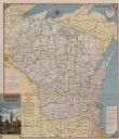
| Description: | This road map shows federal, state and county roads in Wisconsin, northern Illinois, northeastern Iowa, eastern Minnesota, and the western portion of Michi... |

| Date: | 1940 |
|---|---|
| Description: | This tourist map of Door County, Wisconsin, lists the points of interest and tourist hotels, cabins and cottages in the area. Ferry schedules to Washington... |

| Date: | |
|---|---|
| Description: | Color postcard of view across water towards the "Nichevo II" ferry for Bayfield-Madeline Island moving through the water and filled with tourists and their... |

| Date: | 1966 |
|---|---|
| Description: | A colored map depiction of Door County, Wisconsin, with pictorial highlights, titled: "Door County — Wisconsin's Air Conditioned Peninsula Playground." |
| Date: | 1954 |
|---|---|
| Description: | This map is designed to help Catholic tourists in Wisconsin find Catholic churches and missions. On the front side, a road map of Wisconsin showing the loc... |
If you didn't find the material you searched for, our Library Reference Staff can help.
Call our reference desk at 608-264-6535 or email us at: