 Filter: Subject of tourism
Filter: Subject of maps
Filter: Subject of tourism
Filter: Subject of maps
| Date: | |
|---|---|
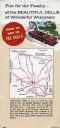
| Description: | Back fold of a Wisconsin Dells promotional brochure featuring a simplified Wisconsin highway map with directions to the Dells, and a drawing of a family dr... |

| Date: | |
|---|---|
| Description: | Wisconsin promotional decal with a map of the state, with many cities marked and drawings of some Wisconsin icons: cheese, cows, deer, beer, Wisconsin Dell... |

| Date: | 1966 |
|---|---|
| Description: | A colored map depiction of Door County, Wisconsin, with pictorial highlights, titled: "Door County — Wisconsin's Air Conditioned Peninsula Playground." |

| Date: | 1919 |
|---|---|
| Description: | This map shows auto trails, main roads, rivers, and populations of communities. The map also shows selected hotels and garages and includes a key in the ri... |

| Date: | 1935 |
|---|---|
| Description: | This blue lined map shows the major roads and cities of Wisconsin. The map includes an index, hotel and cafe advertisements, as well as advertisements for ... |

| Date: | 1935 |
|---|---|
| Description: | This blue lined map ("compliments of Black Eagle Oil Company") shows the major roads and cities of Wisconsin. The map includes an index, hotel and cafe adv... |

| Date: | 1930 |
|---|---|
| Description: | This map shows roads and lakes and includes an inset illustration of Manitowish Waters Fish Hatchery. The back of the map includes a resorts directory, tex... |

| Date: | 1975 |
|---|---|
| Description: | This map shows nature trails, public attractions, public hunting and fishing grounds, dams, waysides, lakes, highways, and roads. The upper right corner in... |

| Date: | 1983 |
|---|---|
| Description: | This map covers Vilas county as well as parts of Iron, Oneida, and Forest counties. Club trails are shown in dotted red lines and state trails are shown in... |

| Date: | 1994 |
|---|---|
| Description: | This map shows historical sites, picnic grounds, public boat landings, canoe and motor boat trips, and resort locations. The left margin of the map include... |

| Date: | 1937 |
|---|---|
| Description: | This map shows the major roads, cities, towns, lakes, and rivers of Wisconsin and some of the neighboring states. The front includes an add for Coca-Cola, ... |

| Date: | 1920 |
|---|---|
| Description: | This map of the entire state shows state and other highways, cities, some lake, the Mississippi River, Lake Michigan, and Lake Superior. The bottom left co... |

| Date: | |
|---|---|
| Description: | Illustrated map of Lake Geneva surrounded by views of points of interest including; Yerkes Observatory, an excursion boat, a pier, a lakeside drive, sailin... |
| Date: | 1931 |
|---|---|
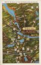
| Description: | Text on front reads: "Map of the Dells of the Wisconsin River Region." On reverse: "All the world knows of the Wisconsin Dells. Many noted travelers have p... |
If you didn't find the material you searched for, our Library Reference Staff can help.
Call our reference desk at 608-264-6535 or email us at: