 Filter: Subject of tourism
Filter: Subject of michigan, lake
Filter: Subject of tourism
Filter: Subject of michigan, lake
| Date: | 1936 |
|---|---|
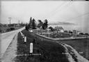
| Description: | Crescent Beach campsite with cabins and miniature golf course by Lake Michigan. |
| Date: | 1906 |
|---|---|
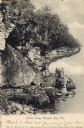
| Description: | View of Lover's Leap with a group of people on the rocks near the shoreline under an overhang. Caption reads: "Lovers Leap, Sturgeon Bay, Wis." |

| Date: | 1954 |
|---|---|
| Description: | View looking west from Eagle Bluff toward Nicolet Bay, the Strawberry Islands, and Chambers Island. Three people are sitting on the stone wall of the overl... |

| Date: | |
|---|---|
| Description: | Map reads: "Historic and Scenic Wisconsin — Land of Gathering Waters." In an inset there is a hand-painted depiction of the Wisconsin State Seal. For some ... |

| Date: | 1957 |
|---|---|
| Description: | Large Letter style postcard for Green Bay depicting various scenes in the letters that spell the name of the city. Caption reads: "Greetings from Green Bay... |

| Date: | 1941 |
|---|---|
| Description: | A map of the area south of Ripon and Sheboygan and east of Waterloo and Janesville, showing the route of the Chicago, North Shore and Milwaukee Railroad in... |

| Date: | 1936 |
|---|---|
| Description: | This pictorial tourist map from the Wisconsin Conservation Commission depicts vacation activities and identifies tourist destinations throughout the state.... |

| Date: | 1950 |
|---|---|
| Description: | This road map shows federal, state and county roads in Wisconsin, northern Illinois, northeastern Iowa, eastern Minnesota, and the western portion of Michi... |

| Date: | 1904 |
|---|---|
| Description: | A brochure for the lake region of north-eastern Illinois and south-eastern Wisconsin providing information on summer activities and places to stay in the a... |

| Date: | 1970 |
|---|---|
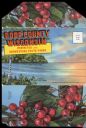
| Description: | A map of parks of Kewaunee County, Wisconsin, showing the fishing spots, lakes and parks in the area, it also provides a location map of the area. On the ... |

| Date: | 1976 |
|---|---|
| Description: | A street map of Milwaukee County, Wisconsin that identifies the location of schools, hospitals, parks, beaches, streets, freeways, both planned or under co... |

| Date: | 1941 |
|---|---|
| Description: | This 1941 tourist map of Washington Island, Wisconsin, shows points of interest and places of business. Some information is shown pictorially. Rock, Hog, D... |

| Date: | 1940 |
|---|---|
| Description: | Shows Milwaukee and Waukesha counties, and parts of Dodge, Washington, Ozaukee, Jefferson, Walworth, and Racine counties. Includes indexes of "Cities, Town... |

| Date: | 1956 |
|---|---|
| Description: | This map of Racine includes a street directory and index of public buildings. Streets, points of interest, Lake Michigan, and the Root River are labeled. A... |

| Date: | 1956 |
|---|---|
| Description: | Intended for tourists, this brochure features a map of Milwaukee's central business district as well as general information about parking, beaches and othe... |

| Date: | 1966 |
|---|---|
| Description: | A colored map depiction of Door County, Wisconsin, with pictorial highlights, titled: "Door County — Wisconsin's Air Conditioned Peninsula Playground." |
| Date: | 1940 |
|---|---|
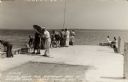
| Description: | Photographic postcard view looking out at people standing, and some fishing, on the Northport pier at Death's Door, with the bay in the background. |
| Date: | 1940 |
|---|---|
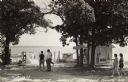
| Description: | Black and white photographic postcard of people on the shoreline and on the pier at Death's Door. Signs on a tree near a snack stand on the right read: "Sm... |

| Date: | 1960 |
|---|---|
| Description: | View across water towards a man, woman, and two children standing on the rock ledge at Cave Point. Lake Michigan is on the right. |
| Date: | 1920 |
|---|---|
| Description: | Envelope cover. Inside are eighteen color enhanced photographic scenes from Door County, Wisconsin, including a short description of Door County features t... |
If you didn't find the material you searched for, our Library Reference Staff can help.
Call our reference desk at 608-264-6535 or email us at: