 Filter: Subject of tourism
Filter: Subject of streets
Filter: Subject of tourism
Filter: Subject of streets

| Date: | 05 21 1935 |
|---|---|
| Description: | International Model C-1 truck parked in front of Edmonton capitol building in Alberta, Canada. The truck was used to promote tourism in Alberta and is pain... |

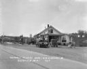
| Date: | 1937 |
|---|---|
| Description: | A group of road repair trucks are parked in a paved parking lot at Niagara Falls, Ontario, Canada. A man is standing near one of the trucks. The original c... |

| Date: | 1937 |
|---|---|
| Description: | Two International D-40 road repairs trucks used by the Brennan Paving Company are parked on the side of the road with men sitting in the cabs. They are in ... |

| Date: | 06 29 1937 |
|---|---|
| Description: | An International D-40 truck used by the Brennan Paving Company is parked in a paved lot in Niagara Falls, Ontario, Canada, while a group of men work in the... |

| Date: | |
|---|---|
| Description: | View from street looking toward a touring car filled with tourists outside of a building lobby with a roof over the sidewalk. Caption reads: "Seeing Kansas... |
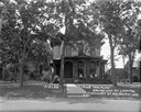
| Date: | 1925 |
|---|---|
| Description: | View across road of a two-story home located on a corner lot at 330 5th Avenue. There are signs on the lawn advertising rooms for tourists. A man is standi... |
| Date: | 1929 |
|---|---|
| Description: | Exterior view from road of gas station and "dine and dance" restaurant on Highway US-18/US-12, outside the Triangle Tourist Park. The establishment offers ... |

| Date: | 1970 |
|---|---|
| Description: | A map of parks of Kewaunee County, Wisconsin, showing the fishing spots, lakes and parks in the area, it also provides a location map of the area. On the ... |

| Date: | 1976 |
|---|---|
| Description: | A street map of Milwaukee County, Wisconsin that identifies the location of schools, hospitals, parks, beaches, streets, freeways, both planned or under co... |

| Date: | 1976 |
|---|---|
| Description: | This 1976 map of Washington County, Wisconsin, shows towns, cities and villages, highways and roads, existing and proposed county trails, and various publi... |

| Date: | 1927 |
|---|---|
| Description: | Map reads: "Now You Can Visualize Madison". Includes indexes, with points marked 1-98 and a key. Text and illustrations on verso include hotels and seasona... |
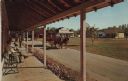
| Date: | 1973 |
|---|---|
| Description: | Color postcard of Main Street from porch on building at Stonefield Village. A horse bus with tourists is in the street. |

| Date: | 1900 |
|---|---|
| Description: | This map of Three Lakes shows forest fire lookout towers, picnic grounds, an airport, roads, and railroad. The map features text boxes on the Village of Th... |

| Date: | 1956 |
|---|---|
| Description: | This map of Racine includes a street directory and index of public buildings. Streets, points of interest, Lake Michigan, and the Root River are labeled. A... |
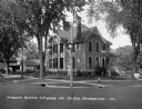
| Date: | 1926 |
|---|---|
| Description: | View from street of a large brick house with an arched entrance and wrap-around columned porch. There are benches on the lawn along the side of the house o... |

| Date: | 1956 |
|---|---|
| Description: | This map is intended for tourists of La Crosse. The front of the map is text about attractions, activities, and accommodations in La Crosse. The back is th... |

| Date: | 1970 |
|---|---|
| Description: | This map is intended for tourists of La Crosse. The cover features images of farms and natural land and reads: "friends are but strangers... we have yet to... |

| Date: | 1959 |
|---|---|
| Description: | This map of Lake Geneva has relief shown by contours and water depths shown by isolines. The map includes an index of schools, churches, public services, i... |

| Date: | 1929 |
|---|---|
| Description: | View across street towards three women standing on the front steps of Winnes Inn, a converted dwelling in a residential neighborhood. |

| Date: | 1931 |
|---|---|
| Description: | View from street of a house in a residential neighborhood with rooms available for tourists. |
If you didn't find the material you searched for, our Library Reference Staff can help.
Call our reference desk at 608-264-6535 or email us at: