 Filter: Subject of transportation
Filter: Subject of human settlements
Filter: Creator Name of Wisconsin. Conservation Department.
Filter: Subject of transportation
Filter: Subject of human settlements
Filter: Creator Name of Wisconsin. Conservation Department.
| Date: | 1935 |
|---|---|
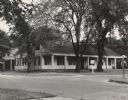
| Description: | Fort Howard hospital sheltered by large trees. |

| Date: | 1949 |
|---|---|
| Description: | Fort Howard Hospital, Surgeon's Quarters. |
| Date: | |
|---|---|
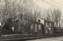
| Description: | The Pendarvis house, a Cornish home on Shake Rag Street. |

| Date: | 1953 |
|---|---|
| Description: | View across water towards the Sturgeon Bay Canal Lighthouse, with a group of people in a motorboat in the foreground. |
| Date: | 1952 |
|---|---|
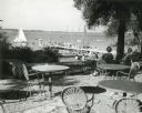
| Description: | University of Wisconsin-Madison Memorial Union Terrace with Lake Mendota and sailboats in the background. |
| Date: | 1935 |
|---|---|
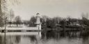
| Description: | Lake Okauchee lighthouse. Buildings are in the background along a tree-covered shoreline. |

| Date: | 1942 |
|---|---|
| Description: | Warden Kramer and an assistant hold up confiscated sturgeon caught with illegal snag lines. |

| Date: | 1933 |
|---|---|
| Description: | This 1933 Wisconsin Conservation Dept. map shows roads, railroads, trails, lakes and streams, and the Trout Lake Game Refuge in Northern State Forest (whic... |

| Date: | 1952 |
|---|---|
| Description: | This Wisconsin Conservation Dept. map shows sections, roads, rivers, and lakes in the Town of Cloverland, Vilas County, Wisconsin as of February, 1952. It ... |

| Date: | 1952 |
|---|---|
| Description: | This Wisconsin Conservation Dept. map shows sections, roads, rivers, and lakes in the Town of Presque Isle, Vilas County, Wisconsin as of March 1953. It do... |
If you didn't find the material you searched for, our Library Reference Staff can help.
Call our reference desk at 608-264-6535 or email us at: