Filter: Subject of transportation
Filter: Subject of indian reservations
Filter: Subject of transportation
Filter: Subject of indian reservations

| Date: | 1936 |
|---|---|
| Description: | This map is red and black ink on tracing cloth and is oriented with north to the upper left. This hand-drawn map shows a central portion of the military ro... |

| Date: | 1886 |
|---|---|
| Description: | This map shows U.S. land offices, completed railroads, railroad land grant limits, lakes, rivers, and Indian reservations. Communities, lakes, and rivers a... |
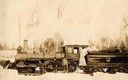
| Date: | |
|---|---|
| Description: | Three men stand in the snow in front of the Wisconsin & Northern Railroad engine #2 (the second locomotive with this number) in the woods on the Menominee ... |
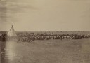
| Date: | 1897 |
|---|---|
| Description: | Slightly elevated view across field of a Sioux women's Episcopal Convocation meeting at the Rosebud Agency. The women, and a number of children, are sittin... |

| Date: | 1896 |
|---|---|
| Description: | This hand-colored map shows counties, county seats, cities, towns, proposed and completed railroads, and U.S. Land Offices. Also included in the map are th... |

| Date: | 1860 |
|---|---|
| Description: | A map of Wisconsin showing the railroads, rivers, counties, cities, villages, and named towns in the state, as well as the township grid for the portion of... |

| Date: | 1880 |
|---|---|
| Description: | A hand-colored map of the Chippewa, Price, Taylor and the northern part of Clark counties, which shows the locations of farmhouses, schoolhouses, churches,... |

| Date: | 1847 |
|---|---|
| Description: | A hand-colored map that shows the area south and east of the Wisconsin and Fox Rivers, as well as a few landmarks just north of that area. The township gri... |

| Date: | 1855 |
|---|---|
| Description: | This map shows the entire state and part of the Upper Peninsula of Michigan. It depicts creeks, rivers, lakes, railroads completed, railroads in progress, ... |

| Date: | 1855 |
|---|---|
| Description: | This Wisconsin map depicts counties, creeks, rivers, lakes, railroads completed, railroads in progress, common roads and the Menomonee Reservation. |

| Date: | 1855 |
|---|---|
| Description: | This map depicts counties, creeks, rivers, lakes, railroads completed, railroads in progress, common roads and the Menomonee Reservation. |

| Date: | 1935 |
|---|---|
| Description: | "Drott's conservation guide" map shows the locations of Indian reservations, parks, fish hatcheries, forests, lookout towers, Wisconsin Conservations Commi... |

| Date: | 1939 |
|---|---|
| Description: | This nine-part map from the U.S. Bureau of Public Roads identifies federal and state highways in Wisconsin by pavement type. County, forest, park, and publ... |

| Date: | 1944 |
|---|---|
| Description: | This nine-part map from the U.S. Bureau of Public Roads identifies federal and state highways in Wisconsin by pavement type. County, forest, park, and publ... |

| Date: | 1950 |
|---|---|
| Description: | This road map shows federal, state and county roads in Wisconsin, northern Illinois, northeastern Iowa, eastern Minnesota, and the western portion of Michi... |

| Date: | 1855 |
|---|---|
| Description: | This map shows the township survey grid and identifies counties, named towns, rivers, lakes, railroads, plank roads, mines, and the Menomonee Reservation. ... |

| Date: | 1856 |
|---|---|
| Description: | This map with an ornamental border shows the township survey grid and identifies counties, named towns, cities and villages, rivers, lakes, railroads, road... |

| Date: | 1856 |
|---|---|
| Description: | This map of shows the township survey grid and identifies counties, named towns, cities and villages, rivers, lakes, railroads, roads, and the Menomonee an... |

| Date: | 1858 |
|---|---|
| Description: | This map of the entire state of Wisconsin depicts the township survey grid and identifies counties, named towns, cities and villages, rivers, lakes, railro... |
If you didn't find the material you searched for, our Library Reference Staff can help.
Call our reference desk at 608-264-6535 or email us at: