 Filter: Subject of transportation, military
Filter: Subject of coasts
Filter: Subject of transportation, military
Filter: Subject of coasts
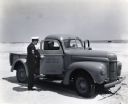
| Date: | 1943 |
|---|---|
| Description: | Two uniformed men sit inside an International K-1 U.S. Coast Guard truck parked on a beach while another man speaks to them through the open passenger door... |
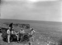
| Date: | 1945 |
|---|---|
| Description: | Leota Kelly, directer of the Pacific Athletic Club, division of the Red Cross, and colleagues, at the site of the new Red Cross Club in Tinian near a cliff... |

| Date: | 02 1777 |
|---|---|
| Description: | Map depicting the campaigns of October and November 1776, in Manhattan, Westchester, and part of New Jersey, published only a few months after the conclusi... |

| Date: | 11 1781 |
|---|---|
| Description: | Map of New York, Staten Island, and Long Island, showing the placements of forts, and the movement of troops in 1776. The map also includes towns, cities, ... |
If you didn't find the material you searched for, our Library Reference Staff can help.
Call our reference desk at 608-264-6535 or email us at: