 Filter: Subject of transportation, military
Filter: Subject of maps
Filter: Subject of transportation, military
Filter: Subject of maps
| Date: | 09 18 1944 |
|---|---|
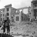
| Description: | Two soldiers in the lower left look at a map. Behind them is what remains of the Brest Post Office. Just under the decorative stone cornice at the top is t... |
| Date: | 03 26 1944 |
|---|---|
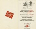
| Description: | Front cover and menu listing from the Villa Ferrovieri in Italy with the Chicago Milwaukee St. Paul & Pacific (CMSP&P) logo printed in red ink on the cover... |

| Date: | 1758 |
|---|---|
| Description: | Map showing lakes, rivers, cities, Native American land, and the boundaries of French and English claims in America and Canada north of New York. A title c... |

| Date: | 1780 |
|---|---|
| Description: | Detailed map of America east of the Louisiana region. It shows forts, cities, borders and boundary lines, Native American land, the post road, mountains, w... |
If you didn't find the material you searched for, our Library Reference Staff can help.
Call our reference desk at 608-264-6535 or email us at: