 Filter: Subject of universities and colleges
Filter: Subject of industries
Filter: Subject of universities and colleges
Filter: Subject of industries
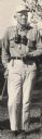
| Date: | |
|---|---|
| Description: | Aldo Leopold, UW Professor of Wildlife Management, posing with binoculars around his neck. He is about to embark on an inspection and bird-watching tour of... |
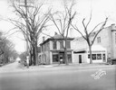
| Date: | 11 28 1927 |
|---|---|
| Description: | View of the 3 F Laundry on the corner of University Avenue and Lake Street, with Holmes Tire, 614 University Avenue, and the Wheeler Conservatory of Music,... |

| Date: | 1867 |
|---|---|
| Description: | Birds-eye drawing of Appleton, Outagamie Co., depicting street names and street layout, houses, the Fox River, the court house, jail, school houses, Lawren... |
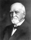
| Date: | |
|---|---|
| Description: | Portrait of Orrin H. Ingram, lumber baron and philanthropist, especially for the development of Ripon College. |
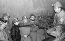
| Date: | 1950 |
|---|---|
| Description: | Students from Platteville, Wisconsin tour a mine to see how lead is extracted. |
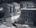
| Date: | 1949 |
|---|---|
| Description: | Elevated view of faculty housing project, under construction on the University of Wisconsin-Madison campus. |

| Date: | 1930 |
|---|---|
| Description: | Mechanical Engineering Building under construction. A group of construction workers are on the foundation are working near a tower. There is a church steep... |

| Date: | |
|---|---|
| Description: | Bird's-eye view of the north branch extension canal on the Susquehanna river, surrounded by smaller renderings of structures of interest around the town in... |

| Date: | 08 03 1905 |
|---|---|
| Description: | Photographic postcard of a scene of the Fox River near Lawrence University. The Main Building at Lawrence University can be seen in the background on the r... |

| Date: | 1842 |
|---|---|
| Description: | This map shows portions of northern Illinois and Wisconsin surveyed by the map's creation. It shows county lines and university land, and depicts lead and ... |

| Date: | |
|---|---|
| Description: | Three-quarter length portrait of Aldo Leopold taken outdoors by his wife. He is wearing a suit and tie. A window, shrubs and a window box are behind him. |
If you didn't find the material you searched for, our Library Reference Staff can help.
Call our reference desk at 608-264-6535 or email us at:
