Filter: Subject of wisconsin river (wis.)
Filter: Subject of aerial photographs
Filter: Subject of wisconsin river (wis.)
Filter: Subject of aerial photographs

| Date: | 1920 |
|---|---|
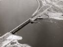
| Description: | Aerial view of the last covered bridge, which is no longer standing. |
| Date: | |
|---|---|
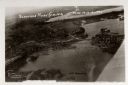
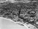
| Description: | Aerial view of the town, including the Wisconsin River, and the surrounding countryside. |
| Date: | 1930 |
|---|---|
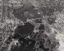
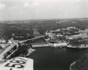
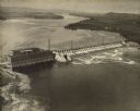
| Description: | Aerial view of the town of Wisconsin Dells, the dam on the Wisconsin River, and the generating plant. The town of Wisconsin Dells was known as Kilbourn Cit... |

| Date: | 1930 |
|---|---|
| Description: | Aerial view of Wisconsin Dells including the Wisconsin River and the dam and generating power plant. |
| Date: | 1930 |
|---|---|
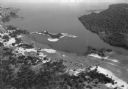
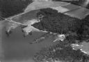
| Description: | Aerial view of Lake Delton, the Wisconsin River, and the surrounding countryside. |
| Date: | 1930 |
|---|---|
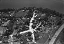
| Description: | Aerial view of Lake Delton and shoreline including resort areas. |
| Date: | 1955 |
|---|---|
| Description: | Aerial view of Wisconsin Dells. The wing of the airplane is in the left foreground. |
| Date: | 1940 |
|---|---|
| Description: | Aerial view of the Wisconsin Power and Light Company generating plant and dam. |
| Date: | 1925 |
|---|---|
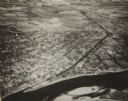
| Description: | Aerial view of buildings in the downtown area. |

| Date: | 1965 |
|---|---|
| Description: | Aerial view that encompasses most of the town and part of the Wisconsin River. |

| Date: | 1945 |
|---|---|
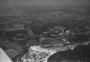
| Description: | Aerial view of Taliesin, Frank Lloyd Wright's residence and architectural school complex, with the Wisconsin River visible at the top. Taliesin is located... |
| Date: | 1926 |
|---|---|
| Description: | Aerial view with Wisconsin River. Caption reads: "Schofield Home Coming June 16-17-18-1927". The wing of an airplane is in the right foreground. |
| Date: | 1955 |
|---|---|
| Description: | Aerial view of Castle Rock Dam on the Wisconsin River. |

| Date: | 1945 |
|---|---|
| Description: | An aerial view of the Portage Canal, Fox and Wisconsin Rivers. |
| Date: | 1945 |
|---|---|
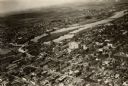
| Description: | An elevated view of Portage and it's vicinity. |

| Date: | 1950 |
|---|---|
| Description: | Aerial view of the Highway 21 bridge and Petenwell Dam on the Wisconsin River. |
| Date: | 1924 |
|---|---|
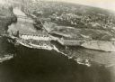
| Description: | Aerial view of the Prairie du Sac hydroelectric plant and the surrounding landscape of the Wisconsin River. |
| Date: | 02 09 1949 |
|---|---|
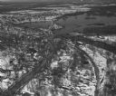
| Description: | One of five aerial views of Portage, including the frozen Wisconsin River. |
| Date: | 04 16 1949 |
|---|---|
| Description: | Aerial view of Necedah, Wisconsin, and Petenwell Lake behind Petenwell Dam on the Wisconsin River. |
If you didn't find the material you searched for, our Library Reference Staff can help.
Call our reference desk at 608-264-6535 or email us at: