 Filter: Subject of wisconsin river (wis.)
Filter: Subject of arts
Filter: Subject of wisconsin river (wis.)
Filter: Subject of arts
| Date: | 1845 |
|---|---|
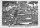
| Description: | Engraving depicting the defeat of Black Hawk by General Henry Atkinson at the Battle of Bad Axe on August 2, 1832. The engraving depicts Federal Regulars a... |
| Date: | 1886 |
|---|---|
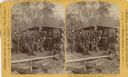
| Description: | Stereograph of a group of men standing and sitting on a raft, watching Dick Stevenson in the center dancing. Zack Dugas is at left clapping time, and Jack ... |
| Date: | |
|---|---|
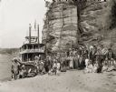
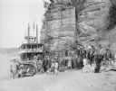
| Description: | Ho-Chunk ceremonial performers posing on the sandy riverbank in front of a steamboat and rock formation. |
| Date: | |
|---|---|
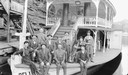
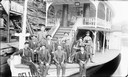
| Description: | H.H. Bennett and men posing on bow of "Dell Queen" steamboat. There are two men with violins, one with a harp. |
| Date: | |
|---|---|
| Description: | H.H. Bennett and group of men posing on bow of "Dell Queen" steamboat. There are two men with violins, one with a harp. |

| Date: | 05 02 1964 |
|---|---|
| Description: | Sitting on the school lawn, students draw Highway 51, Marathon Mill, Rib mountain and the Wisconsin River. |
| Date: | |
|---|---|
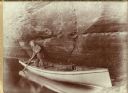
| Description: | Henry Hamilton Bennett poling his boat close along a rock formation in the Wisconsin Dells. |
| Date: | 1929 |
|---|---|
| Description: | Ceremonial performers in traditional Indian costume pose near a steamboat. |
| Date: | |
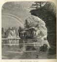
|---|---|
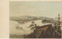
| Description: | Drawing of the mouth of the Wisconsin River from a scenic overlook depicting a steamboat in the distance. Print is part of a series collected in Lewis' "Da... |
| Date: | |
|---|---|
| Description: | Engraved view of "The Jaws" in the Wisconsin Dells. |
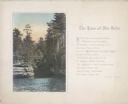
| Date: | 1920 |
|---|---|
| Description: | A hand-tinted photograph of a scene from the Wisconsin Dells is mounted on beige paper upon which is printed a poem written by Alice Kent Trimpey, the wife... |

| Date: | 1986 |
|---|---|
| Description: | Pictorial map showing businesses with phone numbers, roads, railroads, and parks. Includes text titled: "History of Portage County." |

| Date: | 1836 |
|---|---|
| Description: | This map shows lot and block numbers, streets, a proposed canal basin, Fort Winnebago, and the Wisconsin and Fox Rivers. Relief is shown by hachures and no... |

| Date: | 1799 |
|---|---|
| Description: | Map of North America from the Great Lakes region to Baffins Bay. It shows settlements, Native American land, cities, trading houses and forts, mountains, a... |

| Date: | 1718 |
|---|---|
| Description: | First edition of L'Isle's landmark map of North America. It covers America from the Rio Grande to the Atlantic Ocean, showing boundaries, the colonies, cit... |

| Date: | 1805 |
|---|---|
| Description: | Map of the United States. It shows the states, cities, towns, Native American land, mountains, lakes, and rivers. Tennessee, Kentucky, and Ohio are labeled... |

| Date: | 1800 |
|---|---|
| Description: | Map of the United States. It shows the states, including Tennessee, cities, towns, Native American land, mountains, lakes, and rivers. Lead mines appear ju... |

| Date: | 1755 |
|---|---|
| Description: | Map of the Great Lakes region during the French and Indian War. It shows in great detail the territories, borders and boundary lines, Native American tribe... |
| Date: | 1936 |
|---|---|
| Description: | An elevated view towards a Native American man wearing a feathered headdress and a young girl of European descent standing in front of a tepee on the stage... |
| Date: | 1930 |
|---|---|
| Description: | Text on front reads: "Wisconsin Dells." A Large Letter Postcard with a background illustration of Stand Rock and a Native American in a canoe, with a Nativ... |
If you didn't find the material you searched for, our Library Reference Staff can help.
Call our reference desk at 608-264-6535 or email us at: