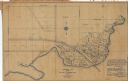
 Filter: Subject of wisconsin river (wis.)
Filter: Subject of cemeteries
Filter: Subject of wisconsin river (wis.)
Filter: Subject of cemeteries

| Date: | 1913 |
|---|---|
| Description: | A wall atlas of Sauk County, Wisconsin, displaying its 22 towns. On the left side are advertisements for local businesses. |

| Date: | 1877 |
|---|---|
| Description: | This 1877 map of Sauk County, Wisconsin, shows the township and range grid, sections, towns, cities and villages, land ownership and acreages, wagon roads,... |

| Date: | 1915 |
|---|---|
| Description: | This map is mounted on cloth and shows lots and landownership, selected buildings, roads, railroads, parks, cemeteries, city wards, and includes advertisem... |
| Date: | 1932 |
|---|---|
| Description: | This blue line print plat map shows local streets, numbered blocks and lots, village limits, and land ownership by name. Also included are manuscript annot... |

| Date: | 1944 |
|---|---|
| Description: | Portage County Map. Includes the towns of Eau Plaine, Dewey, Sharon, Alban, Carson, Hull, New Hope, Linwood, Stockton, Amherst, Plover, Grant, Buena Vista,... |

| Date: | 1914 |
|---|---|
| Description: | Pg. 44 West Half of Marion Township. Pg. 45 East Half of Marion Township. |

| Date: | 1891 |
|---|---|
| Description: | The index page of a Sanborn Map of Stevens Point. |
If you didn't find the material you searched for, our Library Reference Staff can help.
Call our reference desk at 608-264-6535 or email us at: