 Filter: Subject of wisconsin river (wis.)
Filter: Subject of commercial buildings
Filter: Subject of wisconsin river (wis.)
Filter: Subject of commercial buildings

| Date: | 1879 |
|---|---|
| Description: | This map is a bird's-eye view of Wausau, the County Seat of Marathon County. The map features an index of points of interest. |
| Date: | 1928 |
|---|---|
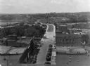
| Description: | Elevated view of the main street with the Wisconsin River in the top left corner. The street just outside the Hall Garage Company is lined with cars. |
| Date: | |
|---|---|
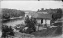
| Description: | Elevated view of the Dells boat landing building, with people standing on the balcony. There is a steamboat near the dock on the river below. |
| Date: | 02 09 1949 |
|---|---|
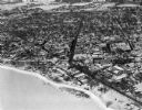
| Description: | One of five aerial views of Portage, including the frozen Wisconsin River. |

| Date: | |
|---|---|
| Description: | Elevated view over trees of the town of Muscoda. The water tower is in the center. The commercial district is on the left, and dwellings are in the foregro... |

| Date: | 1880 |
|---|---|
| Description: | View of flood damage, showing wrecked buildings along the Wisconsin River waterfront. |

| Date: | |
|---|---|
| Description: | Elevated view from bluff of Grand Rapids and the Wisconsin River. |
| Date: | 09 18 1925 |
|---|---|
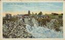
| Description: | Text on front reads: "Paper Mill Dam, Rhinelander, Wis." View of the outflow of the Rhinelander Paper Mill dam, on the Wisconsin River, that powers the mil... |

| Date: | 1900 |
|---|---|
| Description: | A Sanborn fire insurance map of Sauk City created in 1900. |

| Date: | 1915 |
|---|---|
| Description: | A Sanborn fire insurance map of Sauk City created in 1915. |
If you didn't find the material you searched for, our Library Reference Staff can help.
Call our reference desk at 608-264-6535 or email us at: