Filter: Subject of wisconsin river (wis.)
Filter: Subject of foliage
Filter: Subject of wisconsin river (wis.)
Filter: Subject of foliage

| Date: | |
|---|---|
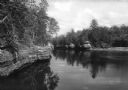
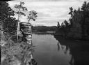
| Description: | View of the Wisconsin River at River Pine Sanitarium, which opened in 1906. Boats are near a small dock to the right. |

| Date: | |
|---|---|
| Description: | Individuals use rowboats near the shore of Marlin's Island on the Wisconsin River. |

| Date: | |
|---|---|
| Description: | View of a sandbar crowded with trees in the Wisconsin River. |
| Date: | |
|---|---|
| Description: | Elevated view from shoreline toward construction workers standing on the Soo Line Railroad Bridge over the Wisconsin River. |

| Date: | |
|---|---|
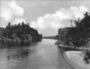
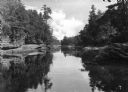
| Description: | Elevated view of the cut-off of the Wisconsin River. Trees line the banks of the river. |

| Date: | |
|---|---|
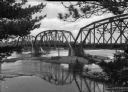
| Description: | View from shoreline looking up at pedestrians and horse-drawn carriages on a wagon bridge that crosses the Wisconsin River. In the foreground is a boat on ... |

| Date: | |
|---|---|
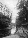
| Description: | View of Echo Dells at the Wisconsin River. |

| Date: | |
|---|---|
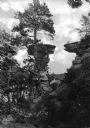
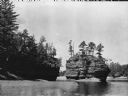
| Description: | View of a rock formation called The Ink Stand located on the Wisconsin River. |

| Date: | |
|---|---|
| Description: | An elevated upstream view of a rock formation in the Wisconsin River known as The Ink Stand. |
| Date: | |
|---|---|
| Description: | Elevated view of the Jaws river segment on the Wisconsin River. The Jaws area is comprised of the space between High Rock and Romance Cliff. |
| Date: | |
|---|---|
| Description: | View of the Narrows, a channel of the Wisconsin River that is 52 feet wide and 100 feet deep. The first bridge spanning the river was built across the Narr... |
| Date: | |
|---|---|
| Description: | Elevated view of the Jaws river segment on the Wisconsin River. The Jaws area is comprised of the space between High Rock and Romance Cliff. |
| Date: | |
|---|---|
| Description: | View of the Sugar Bowl rock formation on the Wisconsin River. The photograph caption reads "Camera Works by Sweet MPLS." |
| Date: | |
|---|---|
| Description: | View of the channel behind Steamboat Rock in the Wisconsin River. |
| Date: | |
|---|---|
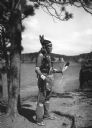
| Description: | View of a Native American dancer at the Stand Rock Indian Ceremonial. The event, which began in 1916, is held on the bank of the Wisconsin River. |
If you didn't find the material you searched for, our Library Reference Staff can help.
Call our reference desk at 608-264-6535 or email us at: