 Filter: Subject of wisconsin river (wis.)
Filter: Subject of food industry and trade
Filter: Subject of wisconsin river (wis.)
Filter: Subject of food industry and trade
| Date: | |
|---|---|
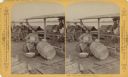
| Description: | Stereograph of a group of men on a raft. The man in the foreground is sitting and peeling potatoes. The young man splitting wood is Ashley Bennett, son of ... |
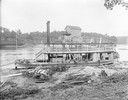
| Date: | |
|---|---|
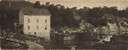
| Description: | View down hill of the "Germania" steamboat along the shoreline in the foreground, across the river from bridge and Munger's Mill, which are in the backgrou... |

| Date: | 1900 |
|---|---|
| Description: | View from bank of river towards the Cereal Mills Company, looking North toward Big Bull Falls. |
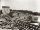
| Date: | 1895 |
|---|---|
| Description: | Munger's Mill and dam, with men standing on and around the dam. |

| Date: | 1835 |
|---|---|
| Description: | Ink on tracing paper map of Green Bay, Wisconsin and nearby areas, Lake Winnebago, Fox and Wolf Rivers, and the junctions of the Mississippi and Wisconsin ... |
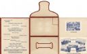
| Date: | 09 05 1926 |
|---|---|
| Description: | Dinner menu for the Hotel Witter, with menu listing, flap, front, and back of self-folding mailer, and tipped-in photographic views of the dining room and ... |
| Date: | 1908 |
|---|---|
| Description: | View of the Rundolph Mill and dam near Muscoda. A man stands near the far side of the bridge on the left. The banks of the river are rocky cliffs, and a st... |
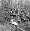
| Date: | 1912 |
|---|---|
| Description: | View towards shoreline of log drivers eating lunch on the edge of the riverbank. Visiting businessmen share a meal with the log drivers who are sitting and... |
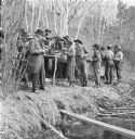
| Date: | 1912 |
|---|---|
| Description: | View towards shoreline of log drivers eating lunch on the edge of the riverbank. The men wait in line along a buffet table filled with provisions. The busi... |
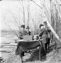
| Date: | 1912 |
|---|---|
| Description: | Four businessmen standing around a table, eating along the banks of the Wisconsin River. The table is set with a stack of bowls and a crate of apples. Logs... |
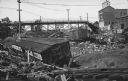
| Date: | 07 23 1912 |
|---|---|
| Description: | Text on front reads: "Below the High Bridge After the Flood. Wausau, Wisconsin." Railroad cars were swept away when dams at Brokaw and Merrill failed on th... |

| Date: | 1892 |
|---|---|
| Description: | A Sanborn fire insurance map of Sauk City which was drawn up in 1892. |

| Date: | 1915 |
|---|---|
| Description: | A Sanborn fire insurance map of Sauk City created in 1915. |

| Date: | 1900 |
|---|---|
| Description: | A Sanborn fire insurance map of Sauk City created in 1900. |

| Date: | 1891 |
|---|---|
| Description: | The index page of a Sanborn Map of Stevens Point. |
If you didn't find the material you searched for, our Library Reference Staff can help.
Call our reference desk at 608-264-6535 or email us at: