 Filter: Subject of wisconsin river (wis.)
Filter: Subject of forests and forestry
Filter: Subject of wisconsin river (wis.)
Filter: Subject of forests and forestry
| Date: | |
|---|---|
| Description: | Elevated view of the mouth of Chapel Gorge Beach showing a canoe at the shore. |

| Date: | 1883 |
|---|---|
| Description: | Bird's-eye map of Sauk City. |

| Date: | 1930 |
|---|---|
| Description: | A view looking west at Rib Mountain across the Wisconsin River from the outskirts of Wausau. |

| Date: | 1900 |
|---|---|
| Description: | Group of four standing on the rocks along shore of the Wisconsin River at the Wisconsin Dells. |

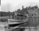
| Date: | 1900 |
|---|---|
| Description: | Crowded steamboat touring the Wisconsin Dells. There is a group of four people standing on the shore of the Wisconsin River looking on. |

| Date: | 1935 |
|---|---|
| Description: | This map shows Wisconsin’s pinery region. Lake Superior, Lake Michigan, Lake Winnebago, Green Bay, the Wisconsin River, and the Mississippi River are label... |

| Date: | |
|---|---|
| Description: | A man and a boy sitting on a rock formation at Devil's Elbow. Text at right: "Wanderings Among the Wonders and Beauties of Wisconsin Scenery." |

| Date: | |
|---|---|
| Description: | Photographic postcard view of a covered bridge over the Wisconsin River. Men are fishing at the base of a pylon, and other men are boating in the river. Th... |

| Date: | 1938 |
|---|---|
| Description: | Elevated view of the Wisconsin River from Bogus Bluff. There is a tree in the foreground and sandbars in the river. |

| Date: | 1926 |
|---|---|
| Description: | Elevated scenic view of the Wisconsin River with rock formations along the shoreline. |

| Date: | 1927 |
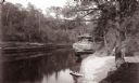
|---|---|
| Description: | The Ravenswood beach on the Wisconsin River. A man is piloting an excursion boat as it is pulling away from the shoreline. Two rowboats are pulled up on th... |

| Date: | |
|---|---|
| Description: | View of the Wisconsin River, with a beach on the left. In the distance is a tree-covered hill. |

| Date: | 1926 |
|---|---|
| Description: | View across Wisconsin River of tree-covered bluffs along the shoreline. |
| Date: | 1929 |
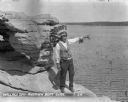
|---|---|
| Description: | Native American tour guide standing on a rock formation. He is wearing a headdress and decorated vest and white shirt, and is holding a megaphone and point... |
| Date: | 1929 |
|---|---|
| Description: | Native American guide in native dress standing on the bow of a tour boat floating in the river. A pilot wearing a hat is sitting behind him. On the front o... |

| Date: | 1960 |
|---|---|
| Description: | Aerial view of the Trees for Tomorrow Environmental Center, with buildings, grounds, roads, and the Eagle River. Founded in 1944. |

| Date: | 08 1960 |
|---|---|
| Description: | This map shows a detailed account of southwestern Wisconsin. Individual settlers, the type of trees that grow in given areas, the quality of the soil (labe... |

| Date: | 1900 |
|---|---|
| Description: | This map shows portion of the military road from Fond du Lac to the Wisconsin River near Fort Winnebago, with mile markers and adjacent land use. A few pro... |
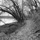
| Date: | 11 2013 |
|---|---|
| Description: | View down a small dirt path lined with grasses and trees along Ferry Bluff State Natural Area. To the left is Honey Creek leading to the Wisconsin River. |
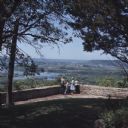
| Date: | 1968 |
|---|---|
| Description: | Slightly elevated view of a family standing in front of a stone wall at Point Lookout in Wyalusing State Park. The man is pointing towards the Wisconsin Ri... |
If you didn't find the material you searched for, our Library Reference Staff can help.
Call our reference desk at 608-264-6535 or email us at: