Filter: Subject of wisconsin river (wis.)
Filter: Subject of indians of north america
Filter: Subject of wisconsin river (wis.)
Filter: Subject of indians of north america

| Date: | 1936 |
|---|---|
| Description: | This map is red and black ink on tracing cloth and is oriented with north to the upper left. This hand-drawn map shows a central portion of the military ro... |
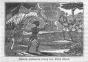
| Date: | 1845 |
|---|---|
| Description: | Engraving depicting the defeat of Black Hawk by General Henry Atkinson at the Battle of Bad Axe on August 2, 1832. The engraving depicts Federal Regulars a... |
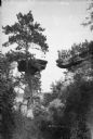
| Date: | |
|---|---|
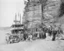
| Description: | Ho-Chunk ceremonial performers posing on the sandy riverbank in front of a steamboat and rock formation. |
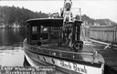
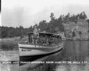
| Date: | |
|---|---|
| Description: | Chief Whirling Thunder, standing at the front of an excursion boat named "Black Hawk," which appears to be near the Wisconsin Dells. Caption reads: "Chief ... |
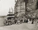
| Date: | |
|---|---|
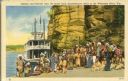
| Description: | Winnebago (Ho-Chunk) Indians posing in front of the steamboat Winnebago near the Stand Rock Amphitheater. This is where the Stand Rock Indian Ceremo... |
| Date: | 1929 |
|---|---|
| Description: | Ceremonial performers in traditional Indian costume pose near a steamboat. |
| Date: | |
|---|---|
| Description: | View of a Native American dancer at the Stand Rock Indian Ceremonial. The event, which began in 1916, is held on the bank of the Wisconsin River. |

| Date: | 1952 |
|---|---|
| Description: | The famous Dells of the Wisconsin River. A souvenir map embellished with bits of history and points of interest. |
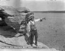
| Date: | |
|---|---|
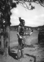
| Description: | An Indian man and boy in native garb stand on High Rock with the Wisconsin River in the background. The man is pointing towards the left and holding a bow ... |

| Date: | 1899 |
|---|---|
| Description: | This color map, originally published in the Smithsonian Institution Bureau of American Ethnology's 18th annual report, shows the Indian land cessions in Wi... |

| Date: | 1900 |
|---|---|
| Description: | A map of Wisconsin, eastern Minnesota and Iowa, northern Iowa, and Michigan’s Upper Peninsula, showing railway lines, with those marked with heavy red line... |

| Date: | 1846 |
|---|---|
| Description: | A map of Wisconsin and a portion of Minnesota that show the township surveys in progress in portions of the Saint Croix River region and in central Wiscons... |
| Date: | 1929 |
|---|---|
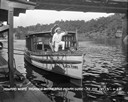
| Description: | View from pier of a Native American man wearing a headdress kneeling on a tourist boat called "Black Hawk" docked under a bridge in the Wisconsin River. He... |
| Date: | 1929 |
|---|---|
| Description: | Native American tour guide standing on a rock formation. He is wearing a headdress and decorated vest and white shirt, and is holding a megaphone and point... |
| Date: | 1929 |
|---|---|
| Description: | Native American guide in native dress standing on the bow of a tour boat floating in the river. A pilot wearing a hat is sitting behind him. On the front o... |

| Date: | 1800 |
|---|---|
| Description: | This map is pencil on tracing paper and shows marshes, the Wisconsin River, Indian trails, and Indian boundary line. The upper left corner reads: "Let sect... |

| Date: | 1838 |
|---|---|
| Description: | This map is a development plat that shows street names, numbered blocks and lots, and small farm lot owners. Included on the right of the map is a large am... |

| Date: | 1853 |
|---|---|
| Description: | This map shows camps, forts, logging camps, lakes, roads, railroads, the Wisconsin River, and Lac Du Flambeau Indian Reservation. Some points of interest a... |

| Date: | 1760 |
|---|---|
| Description: | This map shows lakes, rivers, forts, settlements, and Native American tribal territory. The southern boundary of the Hudsons Bay Company is labeled. Relief... |
If you didn't find the material you searched for, our Library Reference Staff can help.
Call our reference desk at 608-264-6535 or email us at: