 Filter: Subject of wisconsin river (wis.)
Filter: Subject of inland water transportation
Filter: Subject of wisconsin river (wis.)
Filter: Subject of inland water transportation
| Date: | 1886 |
|---|---|
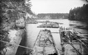
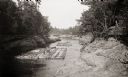
| Description: | A fleet of rafts on the Wisconsin River below the Kilbourn dam. |
| Date: | 1886 |
|---|---|
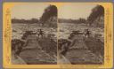
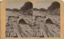
| Description: | Stereograph view of several groups of men on rafts loaded with felled trees. |
| Date: | 1886 |
|---|---|
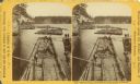
| Description: | Stereograph of a man on a lumber raft steering the raft through the rapids in the Wisconsin Dells. Caption at bottom: The Camera's Story of Raftman's Life ... |
| Date: | 1886 |
|---|---|
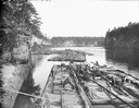
| Description: | A fleet of rafts on the Wisconsin River below the Kilbourn dam. |
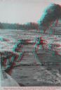
| Date: | 1887 |
|---|---|
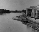
| Description: | Two lumber rafts with men aboard floating down the Wisconsin River. |
| Date: | 1880 |
|---|---|
| Description: | Elevated view of the Wisconsin River shoreline, showing lumber rafts "tied up over Sunday." |
| Date: | 1886 |
|---|---|
| Description: | Stereograph of a man on the end of the raft as he prepares to pass through the water's rough rapids. |
| Date: | 1886 |
|---|---|
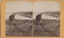
| Description: | Stereograph of a man as he rigs a rope around a log on a lumber raft. |
| Date: | 1886 |
|---|---|
| Description: | Stereograph of a man on a lumber raft steering the raft through the rapids in the Wisconsin Dells. |

| Date: | 04 20 1909 |
|---|---|
| Description: | Photographic postcard of a paddle steamer on the Wisconsin River near Boscobel. Written on the hull of the boat is the text: "Steamer-Grand-Stranded-Near-B... |

| Date: | 1875 |
|---|---|
| Description: | These maps, from G.K. Warren's 1876 Report on the transportation route along the Wisconsin and Fox rivers in the State of Wisconsin between the Mississippi... |

| Date: | 1875 |
|---|---|
| Description: | This map, from G.K. Warren's 1876 Report on the transportation route along the Wisconsin and Fox Rivers in the State of Wisconsin between the Mississippi R... |

| Date: | 1875 |
|---|---|
| Description: | One of a set of maps from G.K. Warren's 1876 Report on the transportation route along the Wisconsin and Fox rivers in the State of Wisconsin between the Mi... |

| Date: | 1887 |
|---|---|
| Description: | Map of the Fox and Wisconsin Rivers to accompany Reuben Gold Thwaites' Historic Waterways. |

| Date: | 1875 |
|---|---|
| Description: | One of a set of maps from G.K. Warren's 1876 Report on the transportation route along the Wisconsin and Fox rivers in the State of Wisconsin between the Mi... |
If you didn't find the material you searched for, our Library Reference Staff can help.
Call our reference desk at 608-264-6535 or email us at: