 Filter: Subject of wisconsin river (wis.)
Filter: Subject of islands
Filter: Subject of wisconsin river (wis.)
Filter: Subject of islands
| Date: | |
|---|---|
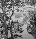
| Description: | Elevated view through trees up the river towards islands, from the mouth of Witches' Gulch. |
| Date: | |
|---|---|
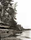
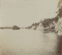
| Description: | Looking upstream towards Blackhawk Island from opposite Ravine Bridge. There is a rowboat at the rocky shoreline. |
| Date: | |
|---|---|
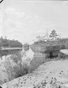
| Description: | View along sandy shoreline towards Ink Stand and Sugar Bowl, south side. |

| Date: | 1870 |
|---|---|
| Description: | Bird's-eye map of Prairie du Sac. |

| Date: | 1883 |
|---|---|
| Description: | Bird's-eye map of Prairie du Sac, Wisconsin with an inset of Clifton. |

| Date: | 1883 |
|---|---|
| Description: | Bird's-eye map of Sauk City. |

| Date: | 1879 |
|---|---|
| Description: | This map is a bird's-eye view of Wausau, the County Seat of Marathon County. The map features an index of points of interest. |

| Date: | 1820 |
|---|---|
| Description: | A manuscript map of Prairie du Chien. |

| Date: | 1840 |
|---|---|
| Description: | This map, one of a series made by Thomas Jefferson Cram of the U.S. Topographical Engineers from personal surveys, shows the portage connecting the Wiskons... |
| Date: | 08 03 1946 |
|---|---|
| Description: | View of the Wisconsin River from Cactus Bluff. |

| Date: | 1828 |
|---|---|
| Description: | Plat of the Private Claims at Prairie Du Chien. |
| Date: | |
|---|---|
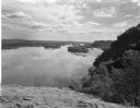
| Description: | View of the Wisconsin River and the surrounding geological landforms. |

| Date: | 1913 |
|---|---|
| Description: | A wall atlas of Sauk County, Wisconsin, displaying its 22 towns. On the left side are advertisements for local businesses. |

| Date: | |
|---|---|
| Description: | Individuals use rowboats near the shore of Marlin's Island on the Wisconsin River. |

| Date: | |
|---|---|
| Description: | View of a sandbar crowded with trees in the Wisconsin River. |

| Date: | |
|---|---|
| Description: | The top elevated view shows the Wisconsin River with several boats. The bottom view includes the river and the Northwestern Railroad bridge from the shorel... |

| Date: | 1920 |
|---|---|
| Description: | A map of the Nelson-Dewey State Park at the confluence of the Mississippi and Wisconsin rivers, showing the topographical features of the area, as well as ... |

| Date: | 1910 |
|---|---|
| Description: | This map shows shoreline lot numbers and acreages, the Wisconsin River, and the Michigan and Wisconsin state line. Manuscript annotations relating to topon... |

| Date: | 1755 |
|---|---|
| Description: | Map of the Great Lakes region during the French and Indian War. It shows in great detail the territories, borders and boundary lines, Native American tribe... |

| Date: | |
|---|---|
| Description: | Elevated view from bluff of Grand Rapids and the Wisconsin River. |
If you didn't find the material you searched for, our Library Reference Staff can help.
Call our reference desk at 608-264-6535 or email us at: