 Filter: Subject of wisconsin river (wis.)
Filter: Subject of locks (hydraulic engineering)
Filter: Subject of wisconsin river (wis.)
Filter: Subject of locks (hydraulic engineering)
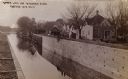
| Date: | 1910 |
|---|---|
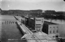
| Description: | The Portage Canal at the Wisconsin River, showing the upper lock. Caption reads: "Upper Lock and Wisconsin River Portage Wis. No. 10". A group of people ar... |
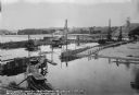
| Date: | 09 12 1911 |
|---|---|
| Description: | An overview of the dam site on the Wisconsin River from the west shore. Three pile drivers are at work on the coffer dam. The railroad trestle is in the ... |
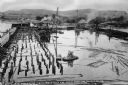
| Date: | 09 18 1911 |
|---|---|
| Description: | Elevated view of pile drivers at work on the coffer dam. Pilings are also floating within the confines of the dam. The shoreline can be seen in the backgro... |
| Date: | 05 13 1914 |
|---|---|
| Description: | A view upstream through the lock at the Prairie du Sac dam. Workmen are guiding a barge through the lock as a man and woman are watching from steps in the ... |
| Date: | 10 11 1914 |
|---|---|
| Description: | Elevated view looking east across the power house, lock, and uncompleted portion of the dam. The concrete plant is seen on the far bank. The rising water o... |
| Date: | 02 28 1915 |
|---|---|
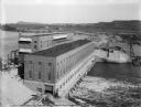
| Description: | Elevated view, looking east, of the power house, lock, and dam on the Wisconsin River. |
| Date: | 08 19 1915 |
|---|---|
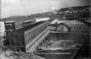
| Description: | Elevated view of the completed power house and dam, looking east at the north, or upstream, side of the structure. On the far shore, the site of the gravel... |
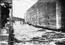
| Date: | 11 01 1913 |
|---|---|
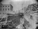
| Description: | Wooden forms are in place for construction of the walls of the lock at the Prairie du Sac dam. The newly constructed power house is on the left. |

| Date: | 1868 |
|---|---|
| Description: | Map showing the northern water routes between Mississippi River and Atlantic Ocean Relief shown by hachures. Includes Profile of the Erie Canal, table of ... |

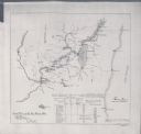
| Date: | 1875 |
|---|---|
| Description: | This map, from G.K. Warren's 1876 Report on the transportation route along the Wisconsin and Fox Rivers in the State of Wisconsin between the Mississippi R... |
| Date: | 1897 |
|---|---|
| Description: | This map shows the distances along Fox River, as well as adjacent lakes and railroads, between Green Bay and the Wisconsin River. Lake Michigan is on the f... |
If you didn't find the material you searched for, our Library Reference Staff can help.
Call our reference desk at 608-264-6535 or email us at: