 Filter: Subject of wisconsin river (wis.)
Filter: Subject of neighborhoods
Filter: Subject of wisconsin river (wis.)
Filter: Subject of neighborhoods

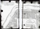
| Date: | 1940 |
|---|---|
| Description: | This map of the Wisconsin Dells shows original plats and various additions. Some streets are labeled as is the Wisconsin River. The map was originally crea... |

| Date: | |
|---|---|
| Description: | Two guest cottages on the edge of the Wisconsin River. Both cottages have screened-in porches. There is a round garden on the lawn surrounded by stones. An... |

| Date: | |
|---|---|
| Description: | Main house for Colburn's Modern Cottages on the Wisconsin River. A curb is in the foreground, and a dirt road leads to a garage and a cottage. An automobil... |

| Date: | 1915 |
|---|---|
| Description: | This map is mounted on cloth and shows lots and landownership, selected buildings, roads, railroads, parks, cemeteries, city wards, and includes advertisem... |
| Date: | 1900 |
|---|---|
| Description: | This map shows lots, public squares, landing, streets, and promenade of a paper city on a site now in the Town of West Point, Columbia County. The Wisconsi... |

| Date: | |
|---|---|
| Description: | Sepia-toned elevated panorama, built from four separate photographs, of Sauk City. The Wisconsin River is in the background, with large hills on the other ... |
If you didn't find the material you searched for, our Library Reference Staff can help.
Call our reference desk at 608-264-6535 or email us at: