 Filter: Subject of wisconsin river (wis.)
Filter: Subject of ponds
Filter: Subject of wisconsin river (wis.)
Filter: Subject of ponds

| Date: | |
|---|---|
| Description: | Stereograph of Bennett's crew hauling a portable darkroom through a pond of water. They are on their way to Stand Rock. Text at right: "Wanderings Among th... |

| Date: | 06 1931 |
|---|---|
| Description: | This map is a photocopy of a map that has been hand-colored and shows streets, the Wisconsin River, Mill Pond, and points of interest that include a school... |

| Date: | 08 1940 |
|---|---|
| Description: | View looking down towards a woman wearing a striped dress and holding a purse standing at a low stone wall at the Point Lookout observation area above the ... |
| Date: | 1909 |
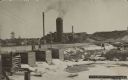
|---|---|
| Description: | Text on front reads: "Brooks & Ross Sawmill & Dam, Schofield, Wis. 1909." The dam and millpond with the sawmill behind it. There are multiple buildings wit... |

| Date: | 1914 |
|---|---|
| Description: | Pg. 44 West Half of Marion Township. Pg. 45 East Half of Marion Township. |
If you didn't find the material you searched for, our Library Reference Staff can help.
Call our reference desk at 608-264-6535 or email us at: